Posts

Showing posts with the label Colorado

The Colorado Midland Railway

Image
The Colorado Midland Railway ran from Colorado Springs to Grand Junction, CO via the Rocky Mountains. ( Right of way ). Between Grand Junction and Glenwood Springs, the road used tracks that were jointly operated by the Denver & Rio Grande Railroad. With its picturesque route through the challenging terrain of the Rocky Mountains, the Midland played a significant role in the transportation history of Colorado. Proposed in 1883, the railway became operational in 1887, connecting Colorado Springs to Grand Junction via the Rocky Mountains.  The construction and operation of the Colorado Midland Railway were formidable tasks due to the difficult trajectory through the mountains. The route, while scenic, presented challenges, especially in the winter when snow persisted until June, rendering operations nearly impossible. Nevertheless, the railway achieved the milestone of becoming the first standard-gauge line in the state to cross the  Continental Divide . Colorado Midland Ra...

The Proposed Canada to Mexico Highway: US Highway 789

Image
US Highway 789 was a proposal for a border-to-border highway running from Nogales, AZ at the Mexican border, to Sweet Grass, MT at the Canadian border. It was dubbed the " Canada-to-Mexico Highway ". It was rejected by AASHTO , given that much of the route would use already existing US Highways (not that that's ever stopped them since). Nonetheless, each state (Arizona, New Mexico, Colorado, Wyoming, and Montana) was interested in a continuous route, and so each created or proposed a Route 789 in their state highway system during the early 1950's. Colorado's 789, sharing pavement with US-160 and the formerly numbered US-666 (now 491 ). Image:   Jim Lindsay In Arizona, AZ-789 was designated in 1956 . Over time, given the duplicative nature of the numbering, each state except for Wyoming chose to remove the 789 designation from their systems.  US 310 in Wyoming, along with WY-789, which was once proposed to be its own US Route. Image:  Jonathan Winkler via AARoads...

Colorado's First Abandoned Railroad: The Arkansas Valley Railway

Image
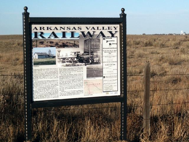
The first railroad abandonment in the State of Colorado was the Arkansas Valley Railway , built in 1872 and abandoned just five years later. ( Right of way ) Photo: Terry Blevins The AVRy was a Kansas Pacific subsidiary, and an attempt by the company to reach Pueblo, CO, after building their mainline through Colorado enroute to Denver. The line ran south from Kit Carson, CO where it met the mainline, and reached 74 miles south to La Junta. The Kansas Pacific and Atchison Topeka & Santa Fe each sent bond proposals to the citizens of Pueblo in an attempt to secure funding to build a railroad line. The AT&SF bond issue won out, leaving the AVRy to serve only the Kit Carson-La Junta route. In 1876, the ATSF finally reached Pueblo, and took nearly all freight and passenger traffic with it, thus rendering the AVRy obsolete. Just one year later, the decision to abandon the Arkansas Valley Railway would make it the first abandonment in the State. Thanks as always for reading!

Colorado's Switzerland Trail: A Brief History

Image
The Switzerland Trail is a hiking, 4x4 and motorcycle trail/road located west of Boulder, Colorado.  What is today known as the Switzerland Trail was first a narrow-gauge railway, which ran along branches from Boulder to Eldora, Gold Hill, and Ward, Colorado. Despite being a rail trail, the name " Switzerland Trail " actually dates back nearly as long as the railroad history of the route does. The first bit of the trail dates back to 1883, when the Greeley Salt Lake and Pacific Railway began grading a right of way. In 1894, a significant flood destroyed the track work that had been done, and the company along with it. In 1896, the project was completed by a new company, the Colorado and Northwestern Railroad. Many spur lines were completed by the CNWR, and it was them who coined the route as the "Switzerland Trail" in an attempt to attract tourists in 1898.  "The railroad changed its focus from industrial use to tourism, taking passengers into the mountains t...

The Colorado Springs & Cripple Creek District Railway

Image
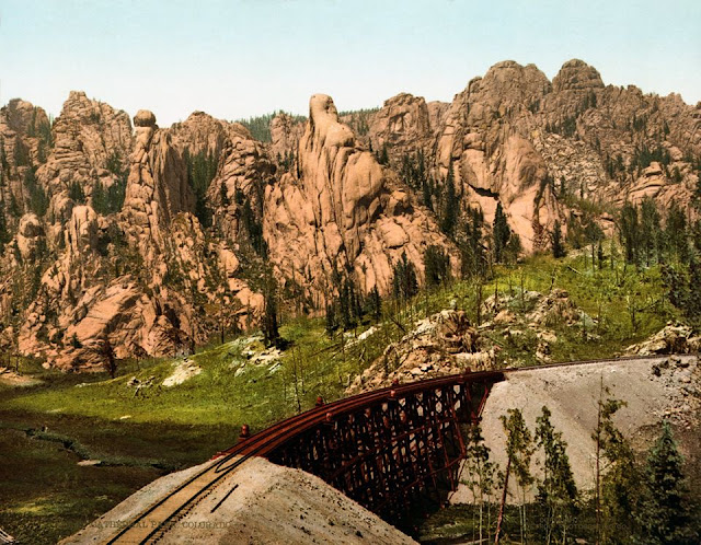
The Colorado Springs & Cripple Creek District Railway connected its namesake towns in Colorado, beginning in 1897, along a right of way over 38 miles in length. ( Right-of-way ) Image: Cathedral Park, Garden of the Gods, Colorado Springs, Colorado . "The train tracks belong to the Colorado Springs & Cripple Creek District Railway." Photochrom print by the Detroit Photographic Co. copyrighted 1901. From the Photochrom Prints Collection, Library of Congress. It was built during Colorado Springs' second gold rush during the 1890's, but faced competition from many of the other railroads built to tap into the mines at Cripple Creek. Despite the rugged terrain it ran through, it was a standard gauge line. Much of the rolling stock of the company, and other companies in the area, was left in the town of Cripple Creek , and were often incorporated into new buildings, or destroyed as time went on. An abandoned car turned building, c. 1960. FRRandP photo collection....

The Straightest Abandoned Track in the US

Image
Railroad lines attempting to brave the terrain of the Rocky Mountains meant that some of the tightest curves ever in the US railroad network were located in the State of Colorado . DRGW 207 at Alamosa, CO. Fireman's Side of Engine, 1907. Image: NG Train Pics But that doesn't mean every railroad line meanders about in the State. Ironically, one of the longest straight (tangent) sections of track was also located in Colorado, along a Denver & Rio Grande Western Railroad line running between Alamosa and Poncha Springs, CO, known as the Valley Line . DRGW.net describes the Valley Line as such, "The original part of the Poncha Pass route, from Mears Junction (joining with the Marshall Pass main line) down to Orient, was initially constructed along with the mainline in 1881. Nearly a decade later in 1890, the line was extended down from Villa Grove to Antonito, CO, where it connected with the existing the existing narrow gauge lines: La Veta Pass, the Antonito Branch, and...