Posts

Showing posts with the label Missouri

The Missouri Southern Railroad (Updated by Brisan Comstock March 2025)
Image
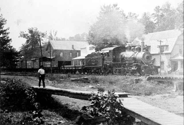
I have once again received more information on this line thanks to the generous help of Brisan Comstock! If anyone has more information on some of our other articles, we are always accepting help towards making each post as accurate as possible! The Missouri Southern Railroad ran an approximately 53 mile line between Bunker, MO, and Leeper, MO, where it connected with the St. Louis Iron Mountain & Southern Railroad . ( Right of way ) Image: A Missouri Southern Railroad engine and cars are stopped at the Ellington Depot. The Masonic Hall (left), Bales Brothers Store (middle) and Dr. Chilton's home (right) are visible behind the train. A man walks on a wood plank footbridge in the foreground . Missouri State Archives , copied from original held by N.J. Shocklette, 1907 The Missouri Southern had its beginnings on January 18, 1884, when five businessmen, two from Oil City, Pennsylvania and three from Ironton, Missouri, met in the small Missouri community of Colemanville in Carter ...

An Abandoned Railroad Bridge is Being Turned Into a Kansas City Attraction

Image
Kansas City will be getting a new attraction in the Summer of 2024, as a new entertainment district, restaurant and trailhead is being built over the Kansas River. The most interesting part of this plan, to me at least, is the fact that they are building it on an abandoned railroad bridge, much like Trestle Park in Milwaukee , but with much larger ambitions! Rendering of the central truss. Image courtesy of Rock Island Bridge. If you are looking for a unique and exciting place to visit in Kansas City this summer, you might want to check out the Rock Island Railroad Bridge , a historic structure that is being transformed into an entertainment district and venue over the Kansas River. (Location on our Railroad Points of Interest Map ) In fact, The Wall Street Journal and New York Times just listed the KC area as a top place to visit in 2024, and Rock Island Bridge was listed as a key reason.  Rock Island Bridge schematic. Image courtesy of Rock Island Bridge. Groundbreaking on the pr...

The Kansas City Clinton & Springfield Railway

Image
The Kansas City Clinton & Springfield Railway connected Olathe, KS with Ash Grove, MO along a 155 mile right of way .  KCC&S Steam Engine , c.1924. Springfield-Greene County Library. Built in 1885, it long paralleled the Kansas City and Southern Railway, which ran a quite similar route in spots. Eventually both lines became part of the St. Louis & San Francisco Railway (" The Frisco "), who would purchase the railroad in 1928, incorporating parts of the line into it's Kansas City-Springfield route, while abandoning most stretches by the mid-1930's. This section was deemed inferior and redundant to the better constructed right of way, leading to its abandonment. The 1894 USGS Clinton Map shows the routes running in parallel to each other, and offers a hint at how close these rights of way were, in some spots running beside each other. Interestingly, much of these parts of the route are underwater today as a result of the construction of the  Truman Reserv...

The Ghost Town of Arlington, Missouri

Image
Arlington, Missouri , once known as "Little Piney", is a near ghost town in Phelps County, MO. Once a stop on the Pacific Railroad, (later the St. Louis & San Francisco Railroad ), it was also a village along the former Route 66 . Today it is incredibly hard to access, as passenger service no longer exists, and it is bypassed by Interstate 44 . ( Location  on our Ghost Towns Map) Trackside at Arlington, MO The town was renamed after Arlington, VA by Thomas and James Harrison, c.1867. At the same time, the " Wire Road " was built during the 1860s through Arlington, next to the telegraph line that ran from St. Louis to Fort Smith in Arkansas.  "Later in the 1920s, the Wire Road was improved and became State Highway No. 14; in 1923 two steel bridges were built on it, one over the railway, the other across the Little Piney River, which runs just south of the town. The state highway became part of U.S. 66 in 1926." (The Route 66) Even before Route 66's ...