Posts

Showing posts with the label airport

Henley Aerodrome: A Landing Strip Turned Silverwood Theme Park

Image
Henley Aerodrome  was a small landing strip in Athol, Idaho which was built in 1973. (Location on our Abandoned Airports Map ) Henely Autodrome Sign. Undated photo via Airfields-Freeman. In 1981, the land was sold, and the landing strip would eventually become part of  Silverwood Theme Park , which it remains to this day. The story of conversion from airport to theme park is one of tragedy and unforeseen circumstances, but also a resolution to rebound from those circumstances, and become bigger and better. It was founded by Clay Henley in 1973, who would pass away just four years later in 1977. During his time, one could ride in an airplane and receive pilot's lessons. Despite, Henley's death, the airport was saved, as it was then purchased by an aviation history enthusiast named Gary Norton, who was looking to build an aviation museum out of the property, similar to the Illinois Aviation Museum on the site of Clow International Airport.  A c.1970's photo by of several bi...
O’Connell Airstrip at La Vérendrye Wildlife Reserve in Quebec

Image
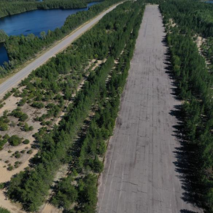
Guest blogger Alain Bernier sent us the blog on an abandoned airstrip in western Quebec off of Route 117. Like many small airstrips over the last half-century, it closed off due to a lack of use. Hope you enjoy exploring more of what the Quebec area's abandoned places have to offer! O’Connell Airstrip, La Vérendrye Wildlife Reserve, Quebec, Canada  © Alain Bernier 2021  The O’Connell Airstrip , also known as the Lac-des-Loups ( lake of the Wolves ) airstrip, is an abandoned landing strip located at Le Domaine in the La Vérendrye Wildlife Reserve in the  province of Quebec, Canada. Although the “ lac des Loups ” was officially renamed “ lac Jean Péré ” in 1935, folks continue to refer to it as the “ lac des Loups ”. The O’Connell airstrip should  not be confused with the closed O’Connell Seaplane Base (ICAO: CSB9) that was located on  nearby lake Jean-Péré.  Hebert J. O’Connell, a local civil works contractor i , built, owned, and operated the expansiv...

Canada's Southernmost Point, Middle Island in Lake Erie

Image
Located at roughly 41.7 degrees north latitude, Middle Island  is the southernmost land point in all of Canada, about 164 yards from the Lake Erie Maritime border with the US State of Ohio.  1955 photo of the  Lighthouse on Middle Island . Ronnie Beatty, courtesy Bruce Beatty On a clear day, it, along with many of the other islands in the Lake Erie archipelago in both the US and Canada (especially Pelee Island ), can be seen from the top of Magnum XL-200 at Cedar Point .  It's nearly impossible to see in the POV, I suggest go visiting it yourself!  Middle Island's latitude means that it is slightly farther south than many parts of the US, and a majority of US States (27/50) have territory above 41.7 degrees north, including California, Nevada, and Utah, which end at the 42nd parallel. It's also slightly farther south than Downtown Chicago, and the entire State of Michigan. While the island is uninhabited today, archaeological study of the island indic...

Airports With Railroad Crossings

Image
Almost every railroad crossing in the entire world is meant for either cars or pedestrians to cross railroad rights of way. But there have been a few railroad crossings across the world where a rail line crosses an airport runway. In Wynyard, TAS, Australia, the Far Western Railway of TasRail once crossed the north end of a runway at Burnie Airport . Imagine the runway delays for this. Image: Airways Museum The railway was constructed along Tasmania's north coast in the early 1920's. "During the late 1930s when the aerodrome at Wynyard was constructed, it was built on the only flat land in the area - the flood plain of the Inglis River. When properly formed runways were constructed, Runway 05/23 was built over the railway line." (Airways Museum) This arrangement was not without precedent in Australia, or in other parts of the world, as Sydney's Airport had a similar crossing before the tracks were relocated. Chicago's Midway Airport also had a simila...

The Abandoned Route 66 in McCook, IL

Image
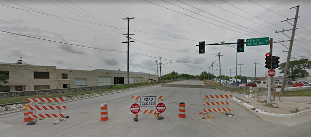
Route 66, the iconic "Main Street of America," weaves through the heart of the United States, connecting communities and embodying the spirit of adventure. However, not all sections of this historic highway have stood the test of time. While much of the former US 66 is drivable in one way or another, especially in Illinois, there are some parts are not.  One of the first such roadblocks for would-be travelers heading from Chicago to Los Angeles via the Mother Road, now known as Joliet Road, comes just outside of Chicago in McCook, IL, where the former highway is closed between 55th St and East Ave, and has been for over two decades. (Link to the location on our Ghost Towns Map ) Image: Google Maps at 55th and Joliet Rd in McCook, IL The land that the quarry would eventually take over was part of Stinson Airport in the early days of Route 66, dating back to before 1930. ( Abandoned Airports map ). 1938 USGS Aerial Imagery The quarrying on the south side of the road would...