Posts

Stenger's Brewery in Naperville, IL

Image
Stenger's Brewery was located at Franklin and Webster Street in downtown Naperville, IL, being the third brewery in the village, and by far the most profitable during its life. At its peak, it shipped 17,000 barrels of lager and ale in northern Illinois. ( Chicago Tribune )  The dates of opening differ depending on the source, but it was first opened by Peter Stenger around 1850, either being purchased from, or opened with, one Jacob Engelfritz and survived until 1893, when Peter's son, John Stenger retired. After Peter, John and his brother Nicholas ran the brewery until  Nicholas' passing in 1864 .  Evidently, the brewery either had a siding for the Chicago Burlington & Quincy Railroad, or otherwise transported their beer another way from the few blocks between the brewery and the tracks. What appears to be a siding on the CB&Q line at Naperville for the brewery. I don't think this is the line which ran along Ewing Street that served the quarry which became...

Route 66 or Route 126?

Image
Like many of the original State Bond Issue (SBI) Routes in Illinois, Illinois Route 126 has existed in a couple different places, and runs an entirely different alignment than its original routing. Today, it exists as a 17 mile , mostly two lane road from Interstate 55 near Bolingbrook to Illinois Route 71 in Yorkville. What makes the 126 number an especially interesting case is how much the highway's history is tied to both Illinois Route 66, which it replaced, and US Highway 66 , which replaced it in two different spots, only for 126 to replace it again  after US-66's decommissioning. IL-126 first came into existence as a road from Springfield to Litchfield. The last sentence was tricky, but the highway replaced both SBI 66 in Illinois, and the Mother Road. Today we're going to explore this interesting quirk in Illinois' State Highway system. US 66 sign just outside Plainfield, IL in the early 1940's, when the road moved from Joliet Road to the present-day IL-126 ...

The Forgotten Railways of Clarinda, Iowa

Image
As I discussed previously with the fate of Anthony, Kansas , there exists other towns in the United States that have been completely separated from the US rail network after having several lines pass through their town, as the railroad network across the United States, and the world, has been rationalized and consolidated over time, leaving us with an incredible amount of data to map . With that in mind, we come to Clarinda, Iowa , county seat of Page County, who was host to five different railroad lines in the city, with at most four running through the town at any given time. Between 1872 and 1911, these lines were built, and in one case, abandoned shortly thereafter.  Today, Clarinda is a case of a county seat that no longer has rail service. The Brownville & Nodaway Valley Railway In 1872, the first railway in Clarinda was built north to Villisca, IA as the Brownville & Nodaway Valley Railway to connect Clarinda with the Burlington & Missouri River Railroad at that...

The Nearly Forgotten Chicago-Kansas City Expressway, and Why Missouri Has Two Highways Numbered "110"

Image
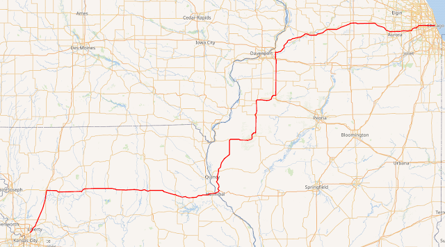
I will start today's blog by stating that I am not a fan of the Chicago-Kansas City Expressway . Or, more specifically, I am not a fan of "Route 110" in either Missouri or Illinois, mostly because it has been functionally obsolete since the day it was first legislated into existence 11 years ago on May 27th, 2010. How is it that a highway designated that recently considered forgotten? Probably because nobody knew what to make of it even when it was originally designed. Even in this article explaining the Chicago-Kansas City route, or CKC, the number 110 doesn't come up once. Today I'm going to explain why I'm not a fan of this road, why it exists, and what I think would help tremendously in making the road a somewhat legitimate part of Illinois' highway system. Wikipedia Commons Map of IL/MO-110 , or the Chicago-Kansas City Expressway, or the *shudders* CKC. Let's start with the actual route itself. Shouldn't a Chicago to Kansas City Expressway b...

Abandoned Railroad Map of Rhode Island

Image
 Last month, I took my data that I'd gathered on Abandoned and Out-of-Service Railroad Lines and created a static map of abandoned lines in the State of Illinois . The reason? I just got a certificate in Geographic Information Science and I want to try my hand at getting better at cartography.  The data I've gathered for the last few years is by and large quite good, although I've clearly made some mistakes in spots. However, I cringe when I see my map shared with the general public, as the design clearly needs improvement. I cringe harder when people don't properly attribute it to this site, but thankfully that's a problem that is usually few and far between. So with this in mind, the second state that I created a static map for is Rhode Island, which is also obviously the smallest US State. I thought it would be Iowa, but I am still working out the kinks in that map, and that state has one of the largest abandoned railroad networks in the US.  In the case of Rhod...

The Greater Grand Crossing Frog War

Image
Greater Grand Crossing is one of Chicago's 77 community areas, and the name derives from a huge crossing between two railroads. Sadly, it was the site of one of the first railroad disasters in Illinois, and indeed the United States, when two trains collided within the crossing. The neighborhood has a rich history dating back to the late 19th century. Originally, the area was mostly farmland until the expansion of transportation and the development of industries in the region. The neighborhood saw an influx of African American residents during the Great Migration, when thousands of African Americans left the South for better opportunities in northern cities. During the 20th century, Greater Grand Crossing experienced periods of growth and decline, but remained a predominantly African American community with a strong sense of community and cultural identity. Today, the neighborhood is working to preserve its historical significance and continue its revitalization efforts. However, t...

Shermer, Illinois: Not Just a John Hughes Set Piece

Image
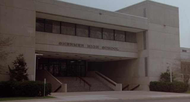
Filmmaker John Hughes made a number of iconic movies in the 1980's, such as Planes Trains & Automobiles , and Ferris Buellers Day Off , two of my all time personal favorites. Shermer High School from The Breakfast Club . The building once housed  Maine North High School . It still stands and is owned as use for offices (and kept in terrible shape) by the State of Illinois. Many of his films were located in/around the North Shore of the Chicago suburbs. Several of these were specifically located in a fictional town called Shermer.  As Jay and Silent Bob would find out  (link is NOT for children) in Dogma , there is no Shermer in Illinois. That being said however, there are numerous real-life references from where Hughes likely took inspiration for the town, including its former name. Shermer is largely based on the Northbrook, Illinois, which was originally named Shermerville . It was, and remains, a stop on the Milwaukee Road, now known as Northbrook Station on Metra...