Posts

Showing posts from September, 2020

The Hanford Site

Image
The Hanford Site is a decommissioned nuclear energy production complex in central Washington State. First developed in 1943, it was part of the Manhattan Project , which culminated in the development of the first successful nuclear weapons. Image: United States Department of Energy - Image N1D0069267., "Nuclear reactors line the riverbank at the Hanford Site along the Columbia River in January 1960. The N Reactor is in the foreground, with the twin KE and KW Reactors in the immediate background. The historic B Reactor, the world's first plutonium production reactor, is visible in the distance." The site expanded to nine nuclear reactors during the Cold War , and would go on to produce most of the plutonium for the United States' arsenal of nuclear weapons. A Milwaukee Road line running from Beverly Junction, WA to Riverland, WA exclusively served the Hanford Site, as did a Burlington Northern running west of Mesa, WA. ( Right of way map ) According to Atomic Heritage

"Not a Prosperous Artery of Commerce": The Ocmulgee Valley Railway

Image
Since much of our understanding of obscure short-line railways comes from Annual Reports, official documents, and other technical manuals, it is quite rare to see such a frank description of a rail line, as the condition of the Ocmulgee Valley Railway was in 1917, which ran between Lumber City, GA and Jacksonville, GA.  Image: A steam engine similar to what would have operated on the Ocmulgee Valley Railway.  It doesn't appear as though any photos exist of the operations. The line developed from the earlier logging railroad known as the Ocmulgee River Lumber Company, and gained independence from said company some time between 1911-1915.  Ocmulgee Valley Railway Right of Way between Lumber City and Jacksonville. The line crossed the ROW of the unrelated Horse Creek Railroad, abandoned about thirty years earlier in 1888. (FRRandP Maps, 2021) By 1917, however, the company was essentially bankrupt, and the lumber company sued the owners of the railroad for non-payment of rolling stoc

Colorado's Switzerland Trail: A Brief History

Image
The Switzerland Trail is a hiking, 4x4 and motorcycle trail/road located west of Boulder, Colorado.  What is today known as the Switzerland Trail was first a narrow-gauge railway, which ran along branches from Boulder to Eldora, Gold Hill, and Ward, Colorado. Despite being a rail trail, the name " Switzerland Trail " actually dates back nearly as long as the railroad history of the route does. The first bit of the trail dates back to 1883, when the Greeley Salt Lake and Pacific Railway began grading a right of way. In 1894, a significant flood destroyed the track work that had been done, and the company along with it. In 1896, the project was completed by a new company, the Colorado and Northwestern Railroad. Many spur lines were completed by the CNWR, and it was them who coined the route as the "Switzerland Trail" in an attempt to attract tourists in 1898.  "The railroad changed its focus from industrial use to tourism, taking passengers into the mountains t

A Day in the Life: The Beatles Song Partially Inspired by Potholes

Image
There may be a lot of potholes in your town/county/state, but it's unlikely that they inspired a line in one of the most famous songs in rock history. Far from Abbey Road, but just up the road from Penny Lane, the terrible road conditions of Blackburn, Lancashire in the UK were newsworthy in the mid-1960's. This newspaper article was one of the inspirations for a new song by the Beatles at the height of their popularity after they stopped touring. "A Day in the Life" is a song by The Beatles, released on their 1967 album "Sgt. Pepper's Lonely Hearts Club Band." The song was co-written by John Lennon and Paul McCartney and is considered one of the most innovative and experimental pieces in the Beatles' catalog. Hand-written lyrics by John Lennon to "A Day in the Life". Image via Reuters. Image A short article in the Daily Mail, "The holes in our roads" noted the prevalence of potholes in Blackburn. That prompted the line "Fou

Securing Coal: The Consolidation Coal Company

Image
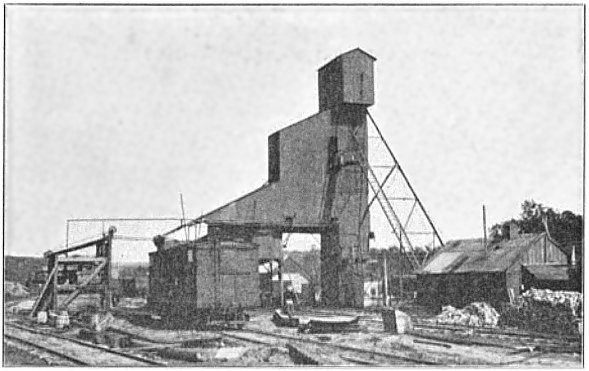
The Consolidation Coal Company (CCC) was an Iowa coal company founded in 1875 to tap into the coal of the south central part of the State.  It was a product of the Iowa Central Coal Company, the Black Diamond Mines of Coalfield, in Monroe County, Iowa, and the Eureka Mine, in Beacon, Iowa. Image: "Figure 56. Steel tipple, showing box car loader. Shaft No. 10, Consolidation Coal Company, Buxton." In 1880, it was purchased by the Chicago & Northwestern Railway to secure a source of coal to power their steam engines. The company hired a large number of African-American workers, and for the most part, paid them equal wages to their White counterparts, in addition to promoting significant numbers to leadership positions. The CNW would built a line from Muchachinock (northeast of present-day Eddyville, IA), and run 34 miles southwesterly toward mining camps known as Consol and Bucknell. The line served both passengers and coal hauling operations, although most of the passenge

The Ghost Town of Arlington, Missouri

Image
Arlington, Missouri , once known as "Little Piney", is a near ghost town in Phelps County, MO. Once a stop on the Pacific Railroad, (later the St. Louis & San Francisco Railroad ), it was also a village along the former Route 66 . Today it is incredibly hard to access, as passenger service no longer exists, and it is bypassed by Interstate 44 . ( Location  on our Ghost Towns Map) Trackside at Arlington, MO The town was renamed after Arlington, VA by Thomas and James Harrison, c.1867. At the same time, the " Wire Road " was built during the 1860s through Arlington, next to the telegraph line that ran from St. Louis to Fort Smith in Arkansas.  "Later in the 1920s, the Wire Road was improved and became State Highway No. 14; in 1923 two steel bridges were built on it, one over the railway, the other across the Little Piney River, which runs just south of the town. The state highway became part of U.S. 66 in 1926." (The Route 66) Even before Route 66's

The Thurso & Nation Valley Railway

Image
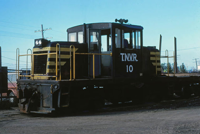
The Thurso & Nation Valley Railway was eastern North America's last logging railroad, ending service in 1986. It connected Thurso, QC with points north, with a 56 mile main line with many branches, as was common with logging lines. Thurso & Nation Valley 10 GE 50 ton Thurso September 1979 . Phtotographer: Bob Heathorn. Image via TrainWeb First surveyed in 1921, the difficult terrain took several years to fully construct, with many unforeseen obstacles along the way. Thurso & Nation Valley Railway Map It faced road competition as early as the 1950's, like every other short line and/or logging railway of the day, but nonetheless it persisted despite economic downturns occasionally closing the line temporarily. "The TNVR was discovered by railfans in the late 1960s and a number of excursions were run by the Bytown Railway Society, a group of railway enthusiasts located in the Ottawa area." (Churcher) But by 1986, operations began to cut back, endi

The Boyne City Gaylord & Alpena Railroad

Image
Boyne City, MI's railroad operations began in 1893 with the creation of the Boyne City Southeastern Railroad , running 7 miles east to Boyne Falls. The line was owned by the W.H. White Lumber Company to tap into northern Michigan's logging industry. Image: Detroit Public Library In 1905, the Boyne City Gaylord & Alpena Railroad  was chartered to succeed the line and extend it to Alpena, MI, 91 miles east of Boyne City. ( Right-of-Way ) Image: Railroad Michigan While expansion took longer than expected, the railroad finally reached Alpena in 1918. Included in the expansion were three branch lines, each of which was used to expand the WH White Lumber Company's land holdings. The land was purchased, cut down, and then marketed to farmers once cleared, who would then benefit from having the BC G & A as a transportation system to the rest of the US railroad network. Unfortunately, Michigan's short growing season, and the lack of fertile soils along

Airports With Railroad Crossings

Image
Almost every railroad crossing in the entire world is meant for either cars or pedestrians to cross railroad rights of way. But there have been a few railroad crossings across the world where a rail line crosses an airport runway. In Wynyard, TAS, Australia, the Far Western Railway of TasRail once crossed the north end of a runway at Burnie Airport . Imagine the runway delays for this. Image: Airways Museum The railway was constructed along Tasmania's north coast in the early 1920's. "During the late 1930s when the aerodrome at Wynyard was constructed, it was built on the only flat land in the area - the flood plain of the Inglis River. When properly formed runways were constructed, Runway 05/23 was built over the railway line." (Airways Museum) This arrangement was not without precedent in Australia, or in other parts of the world, as Sydney's Airport had a similar crossing before the tracks were relocated. Chicago's Midway Airport also had a simila