Posts

Showing posts from September, 2018

South African Railways' Ladismith Branch

Image
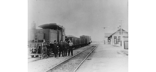
The Ladismith Branch of South African Railways ran between the inland towns of Touws River and Ladismith. ( Right of way ) "Ladismith - May 1962 - photo courtesy the photographer © CP Lewis - The resting Class 7 No 987 looks towards the goods shed and station buildings of Ladismith station." (Via Steam Locomotives South Africa ) Nicknamed the Makkadas line (pronounced: MACK-uh-DASS), it began operations in 1925 after two years of construction. "Plathuis had a shop and old-fashioned petrol bowsers. It is situated in the shadow of the Anysberg, a sort of continuation of the Swartberg, not so high but even wilder.  No 984 was departing with the eastbound Makadas in 8/1970." (Via Soulo Railway ) The line served three trains per week in each direction, and was the only form of transportation before the road network was built through the area. The first of a 3-part video series on the train is shown on a YouTube video below:  In 1981, much of the 88 mile line was destroy

The Deep Creek Railroad

Image
The Deep Creek Railroad ran 45 miles between Wendover and Gold Hill in far Western Utah. The line also briefly crossed into Nevada, as a good chunk of the right of way ran due north-south immediately east of the Utah/Nevada State Line. In The History and Economics of Utah's Railroads, David Johnson wrote of the railroad, ""The Deep Creek Railroad was a mining road which was abandoned from causes other than the depletion of the mines. In this case, however, the causes were similar. The main traffic over the Deep Creek road was copper ores from the area around Gold Hill. As development of the mines progressed, the arsenical content of the ore became so high that it could no longer be smelted. Since the ore in this form was not acceptable it was no longer shipped, and the most important source of revenue of the railroad was eliminated. This line showed an operating profit for only three or four of the years of its existence, and the petition for abandonment was granted.&quo

The Junction City and Fort Kearney Railroad

Image
The Junction City and Fort Kearney Railroad was created in 1871 as a Central Kansas Railway subsidiary. It ran northward from Junction City, KS northerly toward Clay Center, which opened in 1873. By 1878, it reached Concordia. ( Right of way ) Image: "Railroad junction of the Kansas Pacific and Junction City and Fort Kearney Railways in Junction City, Kansas. Courtesy Southern Methodist University, Central University Libraries, DeGolyer Library. Photo by Robert Benecke, 1873." It, along with the Kansas Pacific, was merged into Union Pacific in 1899, making the line UP's Junction City Branch. For most of the right of way, especially north of Clay Center, it was adjacent to the Chicago Rock Island & Pacific Railroad. The Belleville Branch would connect the line to Belleville, KS from a junction just east of Concordia. North of Clay Center, the line was abandoned in 1933; with the aforementioned Belleville Branch ending service in 1934. South of Clay Center, the origina

The St. John & Ophir Railroad

Image
The St. John & Ophir Railroad connected with the Oregon Short Line Railroad, later part of the  Union Pacific Railroad at St. John, UT with the Silver mines at Ophir, UT , located about 9 miles to the east. ( Right of way ) St. John & Ophir Railroad No. 1 in Ophir, Utah. July 5, 1912. George Pitchard--Donor. Attempts at building a railway to tap into the mines and claims around the Ophir area had been proposed since as early as the 1870's, but it wouldn't be until much later that any actual construction would take place. The line was built in 1912 to great fanfare, but would be abandoned fairly quickly after ores began depleting during the 1920's. It ceased operation in 1926, and was fully abandoned two years later. St. John & Ophir #1 at St. John Station on the Oregon Short Line, c. 1922 . George Pitchard--donor. (University of Utah) Despite the length of time this line has been abandoned, the western end is quite easy to spot in the arid desert terrain of ce

The Tallulah Falls Railway

Image
The Tallulah Falls Railway ran approximately 58 miles from Cornelia, GA to Franklin, NC. It was the product of decades of attempts at connecting the two states via the mountains, with the first attempts and proposals coming as early as 1836.  A northbound freight train comes into Clayton, 1946.  (F.E. Ardrey Collection) It was later to become part of the Blue Ridge Railroad, which itself would not be completed, save for a small bit of railroad grade and the Stumphouse Tunnel, which remain today as part of the Blue Ridge Historical Trail, about 12 miles east of this line in South Carolina. Stumphouse Tunnel (SC Picture Project) "In 1854, construction began on the abortive Blue Ridge railroad intended to link Anderson, SC with Knoxville, TN. The state of Georgia got involved by chartering the "North Eastern Railroad" in 1854 to link from Athens to the proposed Blue Ridge line at Clayton, but no actual construction on the North Eastern commenced until after the war, in 18

Avalanche at Timber Falls Amusement Park

Image
The Avalanche at Timber Falls Adventure Park in Wisconsin Dell s, WI was one of the few wooden roller coasters built by S&S . One of the more modern coasters to be demolished, it was built in 2004. It was also briefly known as HellCat late in its life. CoasterForce provided a POV of the ride below: While the track was only 90 feet tall and 2,400 feet long, its stats were not demonstrative of the ride experience, as it was quite intense and fast despite its small size. It also overlooked a relatively steep hill, making it seem taller than it actually was.  Unfortunately, as can be the case with a major attraction in an otherwise very small amusement park, regular maintenance was not prioritized in a way that it would be at larger, regional theme parks, and the ride experience quickly suffered as a result. Initially ranked as one of the best wooden coasters in the United States , by the end of its life it developed a reputation as an extremely rough and unenjoyable ride.  By 2017,

An Unsung Casualty of War: Korea's Gyeongwon Line

Image
War is hell . Of the many numerous tragedies and casualties of the Korean War , one you might not think of immediately is on the Korean Peninsula's infrastructure. But this just shows how damaging war can be. After all, numerous rail lines existed before the War, some of which crossed the 38th Parallel . The Gyeongwon Line was one of these railroad lines which closed following the division of Korea into North and South.  The line ran between Gyeongseong (Present Day Seoul) and Wŏnsan in what is now the Democratic People's Republic of Korea. Image: Cheorwon Station by Mer du Japon ( Wikipedia Commons ) Its birth, however, was in war as well, as it was built by the Chosen Government Railway , which was the state-owned railway when Korea was occupied by the Japanese, opening in stages between 1911-1914.  Sustaining heavy damages in the Korean War, the line was nonetheless mostly rebuilt in the now two countries, to Sintan-ri Station in South Korea, and Pyonggang Station in Nort

Anthony, Kansas: The Town Forgotten By The Railroads

Image
Anthony, KS is a small town in southeastern Kansas, about 50 miles southwest of Wichita. It was incorporated in 1878, and known as a town quite rich in agriculture, with excellent well water, according to their  village website . Atchison Topeka & Santa Fe Railway Depot, 1927. Source: Kansas Historical Society A politician in the early 20th Century remarked of the town, "The center of a great and productive trade territory. The best of municipal services; the finest of schools; amply supplied churches, peopled with the best folks on earth and with a network of railways leading out every direction everywhere , to bring in a constantly increasing business, (Anthony) is the queen city of southern Kansas and the best place on earth to live..." Anthony, KS in 1902, celebrating the first spike being driven on the KC M&O Photo: Kansas Historical Society It's population has remained roughly the same since the early 20th Century, peaking at about 2,900 in the 1930

Nosodak, ND: Abandoned Before it Could Even Become a Ghost-Town

Image
Nosodak, ND, a portmanteau  of sorts of NOrth & SOuth DAKota was a proposed townsite located on the Missouri River immediately north of the South Dakota border. The name was coined by  The Western Townsite & Development Company  noting its geographical location. In 1910, It was planned to be a station on the Northern Pacific Railway's overly ambitious expansion from Mandan, ND to Galveston, TX, which it inherited from the Midland Continental Railroad , who planned a similar route starting in Winnipeg, MB.  At least the Midland Continental wound up opening 86 miles of railroad; the Northern Pacific line south of Bismarck completed less than fifty. Digital Horizons Online Map of North Dakota , 1914. Ghost Towns Map of the townsite. The line would only be constructed to near Carnigan , ND, about 20 miles north of Nosodak's proposed location, and what was built of the route has since been abandoned.  Another NP line emanating from Cannon Ball, about 15 miles north of Carni

The Rockaway Valley Railroad - One of New Jersey's Earliest Railroad Abandonments

Image
The Rockaway Valley Railroad was a short line railroad extending from White House Station on the Central Railroad of New Jersey ,  to Watnong, NJ near present-day Morristown, NJ, just over 24 miles north along a northeasterly route. ( Right of way ).  A northern extension that was never built would have connected the road to Morristown and the Delaware Lackawanna & Western Railroad's Morristown-Essex Division. Photo from Tom Taber III , “The Rock -A-Bye Baby, A History of the Rockaway Valley Railroad” Constructed mainly to aid in New Jersey's peach industry in 1888, traffic along the line would only last about 25 years, although it would also haul passengers and other freight. Like many short lines of the day, it was constructed cheaply, and thus accidents and derailments were common along the line. However, even before the line began service, the peaches in its first year were blighted as a result of a pathogen. Sadly, this would set the stage for the rest of the railro

Japanese National Railway's Shihoro Line

Image
The Shihoro Line was a specified local line of the  Japanese National Railways  system, connecting Obihuro at the Nemuro Main Line with Mitsumata in the Hokkaido region. It opened in sections between 1925 and 1939, it ran approximately 50 miles through mountainous and river terrain. ( Right of way ) ( Wikipedia Commons ) Abandoned  Taushubetsu Bridge   of the old Shihoro line, this section was dammed, with the tracks moved slightly to the west. Now both alignments have been abandoned. With the construction of the Nukabira Dam in 1955, the original alignment was relocated, leaving the Taushubetsu Bridge (pictured above and below) abandoned at that time. Train crossing the Taushubetsu Bridge. Image: Kamishihoro Town Rail Museum The area north of Nukabira was isolated with no means of transportation other than railroads for some time after World War II, but this changed when Japanese National Route 273  was built, paralleling the Shihoro Line. The area also began a steep population de