Posts

Showing posts from May, 2020

An Experimental Military Railway: The Claiborne-Polk Military Railroad

Image
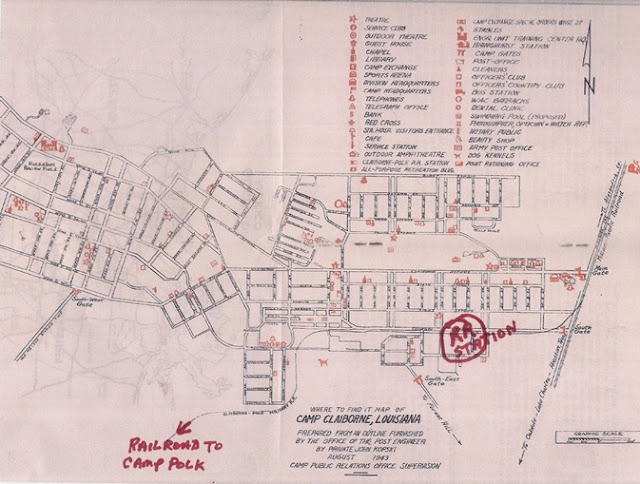
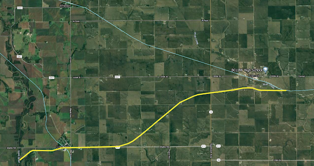
The Claiborne-Polk Military Railroad was a railroad operated by the United States Army at Camp Claiborne in central Louisiana during World War II .  On the east end, it connected to the Missouri Pacific near Alexandria, LA, and on the west, the Kansas City Southern near Leesville, a distance of about 48 miles. The somewhat-abridged version of the right of way is viewable on our map. Claiborne-Polk Military Railroad Map. Image: Robertson Collection The railroad was built to simulate how railroads would operate in and around a war theater. Experiments in sabotaging tracks were undertaken here, as were how repairs of the railroad would work in the war environment. One such operation is filmed below, and it shows just how incredibly resilient trains of the day were to sabotage. This YouTube video shows an experiment on how much track would have to be compromised for a derailment to occur with a steam engine. The trains mostly stay on the tracks, even when relatively large gaps of trac

Highways Over The Water - US 9 and US 10

Image
There are two highways in the US,  US-9 and US-10 , which have ferries that traverse waterways that would otherwise be considered gaps in their routes.  US-9, a prominent U.S. highway, had a peculiar gap in its route until 1964. It used to terminate at Lafayette Street in Cape May, New Jersey, facing the imposing Delaware Bay, making it appear as though the road just ended abruptly. The gap was eventually bridged with the introduction of the  Cape May–Lewes Ferry  service in 1964. This ferry enabled US-9 to continue its journey, now running through Delaware, from Lewes to Laurel, where it meets US-13. Image: Corco Highways US-10 was considered to have a gap in it until 2015, when the Historic SS Badger Ferry was officially codified into the route, traversing Lake Michigan between Ludington, MI and Manitowoc, WI.  The complexities of US geography are to blame for these gaps, as well as a land gap of US 2. Though, in the original 1925 plan of the US Highway system, only US-2 was plann

Is That Enough Warning Lights? The World's Largest Railroad Crossing

Image
This is neither forgotten nor abandoned as of this writing, but this railroad crossing signal gantry is something too unique not to share. This has got to be the world’s largest railroad crossing signal assembly (and if it isn’t, please share what is, because I'd love to see it). Here, in all its glory, is what I believe is officially the Dorcas at 3rd St Railroad Crossing (DOT Number 854667T). I could be wrong since the DOT Numbers  do not always have the best descriptions as to their location, but this seems to be the location. Image: Cliff Trice, St. Louis, MO via the Railroad Signals Facebook group. This railroad line serves the Anheuser Busch Brewery in St Louis, and crosses a warehouse loading dock, hence the need for this extremely large railroad crossing. Thus, the public rarely gets to see this view. Whether "need" is the right word is up for interpretation, since I'm certain there are other industrial operations which go through loading docks. Trains couldn

The Kenosha & Rockford Railroad

Image
The Kenosha & Rockford Railroad , or the KD Line, was first organized by Kenosha area businessmen as the Kenosha, Rockford and Rock Island Railroad. First proposed to connect Kenosha with Beloit, WI, Beloit showed little interest in the road, and promoters chose to connect the line to Rockford, IL instead, a distance of 68 miles. It opened in 1861 after eight years of planning and construction.  Image: Mark Atkinson Collection via AbandonedRails.com The line transported passengers between the two cities, often to tourist sites near Silver Lake and Twin Lakes, WI. Those same lakes became important sources for ice before the days of refrigeration. Two ice spurs connected to lakes at Paddock Lake and Powers Lake Shown in Periwinkle are the ice spurs this line connected to. The abandoned mainline is in blue. Image: Abandoned & Out-of-Service Railroad Lines Early in the 20th century, it was acquired by the Chicago & Northwestern Railway , who named it the Kenosha Division, or &q

The Sardis & Delta Railroad

Image
The Sardis & Delta Railroad originally started life as a logging railroad between Sardis, MS and Bobo, MS, beginning service in 1900. ( Right of Way ) Image: Sardis & Delta Steam Engine #10. Gil Hoffman Collection "The story begins as C. M. Carrier’s hemlock sawmill at Carrier, Pennsylvania, cut out and closed in 1897. As an investment, Carrier purchased a tract of 35,000 acres of hardwood timber land in Panola and Quitman Counties, Mississippi. After a cruise was made to determine the value and quality of the timber, Carrier decided to build a sawmill to cut this timber instead of selling it as originally planned. The business was known as C. M. Carrier & Son. A single band sawmill was built on the south side of Sardis, a town on the Illinois Central mainline." (MS Railroads) Built to somewhat higher standards than some other logging railroads, it nonetheless had a minimum of grading, and thus the line was curvy and hilly. Many logging spurs were built, in addit

El Firdan Railway Bridge - A Bridge Not Far Enough

Image
In the context of railway infrastructure, "Transcontinental" typically refers to the original Transcontinental Railroad , particularly in the United States. But very few pieces of infrastructure can truly be considered transcontinental.  One that can be considered is Egypt's El Ferdan Railway Bridge  ( Google Maps ), which is a dual swing bridge that spans the Suez Canal , connecting Africa with Asia. The bridge opened in 2001, and is (or was) the longest swing bridge in the world. Between 2001-2015, it served the Egyptian National Railway .  Railway bridges over the Suez Canal have had a tendency to not last very long, as it was the fifth bridge over the Suez Canal built in that location.  The first bridge over the Suez was built in April 1918 for the Sinai Military Railway , but removed after World War I as it was a hindrance to shipping.  A swing bridge built in 1942 was removed in 1947 after being damaged by a steamship.  A dual swing bridge replaced it in 1954, but

The Dulaney Railroad: Delaware's First Abandoned Railroad

Image
Within the State of Delaware, the first railroad built south of the Chesapeake & Delaware Canal was also the first railroad abandoned within the state, known as the Dulaney Railroad.  Rough trace of the Right of Way  from our Abandoned Railroads map. Walter Dulaney owned land in western Delaware about six miles west of present-day Clayton. The area was eventually known as "Dulaney Manor" or simply "Dulaney".  The land at the time was heavily timbered, and to clear land for farming, in addition to making money from the timber industry, a railroad was constructed from Dulaney east to a point on the Smyrna River known as  Brick Store Landing, where the timber could be shipped. Image: Delaware DOT . Note the Dulaney RR in the central part of the state. Operation began in 1849, using wooden rails for the roughly 10-mile distance , and ended just one year later. Using a single horse for power, it was not a common-carrier railroad, and built for and used exclusively by

The Rio Grande Railroad

Image
The Rio Grande Railroad ran from Brownsville, TX to Port Isabel, TX, and was first completed in 1872 as a narrow gauge railway. It functioned primarily as a freight line to transport goods from the coast into northern Mexico. "Rio Grande Train: oldest Railroad in Texas. Built 1868." NOTE: TSHA gives an 1872 date, and that's the one we're using. It was also far from the oldest railroad in Texas. Image:  Texas Postcards "The Rio Grande was the only railroad in Texas and one of the few in the United States to be built to a track gauge of forty-two inches. Its route was relatively direct from Brownsville to the coast but required fifteen bridges, including a 15,550-foot trestle across the Badilla Grande." (Texas State Historical Association) The line defaulted in 1910 but was reorganized, and moved its track northward, avoiding the coastal areas that had left the road highly vulnerable to hurricanes and floods. It was converted to standard gauge in 1925, but t

From Humble Beginnings: The Genesee & Wyoming Railroad

Image
Known today as a railroad holding company with numerous short-line railroads in its portfolio, the Genesee & Wyoming itself started as a short-line railroad in Upstate New York, running 14.5 miles between Retsof and Caledonia, NY. Genesee & Wyoming Railroad 17 Steam Engine The railroad first ran in 1891, after salt deposits were discovered within Wyoming County, NY, and was then named the Genesee & Wyoming Valley Railway . A financier, William Foster Jr, invested in a project to mine the salt, and a town grew as a result. It was named " Retsof ", or "Foster" backwards. From Retsof, two spurs were located to the east and west of the town to connect with the other railroads in the area, namely the Western New York & Pennsylvania Railroad , and the Delaware Lackawanna & Western . In 1894, the line north to Caledonia was completed. In 1899, it omitted the "Valley" in its name, and other than abandoning a connection to Cuylerville, NY in 1

Frisco, Utah: A Southern Utah Ghost Town

Image
Frisco is now a ghost town in southern Utah, but during its 1885 peak had a population of over 6,000 people, sustained by nearby mining activity. ( Location on our Ghost Towns map ) The San Francisco Mining District was established as zinc, copper and precious metals were discovered in 1875. By 1879, Frisco was established, and the Utah Southern Railroad had built an extension from Milford, UT , to serve the town. By 1885, over $60,000,000 in minerals had been transported from around the town. Image: Beehive Coke Ovens, Utah State Historical Society However, Friday the 13th would not be kind to the town in February, 1885. The Horn Silver Mine , one of the local mines in the area, completely collapsed. Further mining in the area began to decline in production and profit. Never fully recovering, Frisco's population quickly dwindled to about 500 by the turn of the century, and less than 100 by 1920. It was completely abandoned in 1929. Nonetheless, the Frisco Branch of the USRR, wh

Iowa's First Abandoned Railway: The Farmers Union Railroad

Image
Despite being one of hundreds of failed short-lined railroads throughout the United States, the Farmers Union Railroad is notable for a number of reasons. In 1875, the company was incorporated in the State of Iowa to build a road from the Mississippi River to the Missouri River in the central part of the state, a distance of about 300 miles. What wound up being built was a wooden-railed, narrow-gauge railway between Liscomb, IA and Beaman, IA, roughly between 10-12 miles in length. One engine and 10 cars was all the company could afford to run the route. As a result of poor construction, rolling stock, and lack of financing, the railroad lasted only months into 1876. I simply can't imagine a wooden railway operating anywhere near the length that the original charter for the road was considering. From Liscomb east to Beaman, IA, almost no trace of this railroad exists today, and as far as we can tell, no photographs exist of the road itself. By virtue of its 1876 abandonment