Posts

Showing posts from June, 2019

Railroad University: Abandoned Spur Lines Near Colleges

Image
Spur tracks serving industrial outfits used to be much more numerous than they are now, before competition from the trucking industry made many of them unprofitable. Many colleges and universities in the early 20th century were directly or indirectly served by railroad spurs, some built specifically for the college, others built to serve nearby industries. Notre Dame & Western Railroad #5352, serving Notre Dame University. Image: Dick Leonhardt With that in mind, today's blog will be on these railroads and spurs that served universities. #1.) & #2.) Notre Dame & Western Railroad and St. Mary's Railroad - South Bend, IN I was notified of these sister lines by Tom Burke, who noticed their earlier omission on my abandoned railroads map. Image: Notre Dame University Archives What makes these lines unique is that they actually were separate entities in the railroad world, the Notre Dame & Western Railroad began service in 1902, splitting off from the
The California Cycleway: A Tollway For Bikes

Image
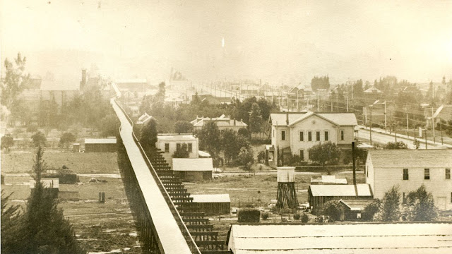
The California Cycleway was an elevated bicycle path in Pasadena, California., and was a short-lived, tolled, “bike highway”, not unlike the linear parks of today, minus the tolls at least. It first opened in 1900, and was planned to run nine miles in length between Los Angeles and Pasadena, CA.  Despite its failure, the Cycleway would inspire future highway design, and was an early example of grade separation between pedestrian traffic and automobiles and trains. California Cycleway looking south from Hotel Green, c.1900 Its 15 cent toll was too high to attract riders, but too low to fund more than 1.4 miles of construction, of what was a 9 mile proposal, which included a never built casino at one end. The cycleway was financed entirely by private parties, unlike road projects of today. Although the project received a great deal of attention and support from the public, it was ultimately never completed. The California Cycleway was plagued by financial difficulties, and a lack of gov

The Forgotten Railways of Chicago: The Bloomingdale Line (a.k.a The 606)

Image
The 606 , or the Bloomingdale Line, is undoubtedly the most famous abandoned rail line turned linear park in the Chicago area, but it's far from the only one. The Illinois Prairie Path , Great Western Trail , Major Taylor Trail , and the under-construction El Paseo Trail are examples as well. What sets the 606, otherwise known as the Bloomingdale Trail apart from the rest of these, however, is that it sits on former elevated right of way, more resembling the High Line  in New York City. In fact, both railroad lines have a similar beginning, in the sense that both were surface lines before being raised due to safety concerns. What we're left with is a wonderful park to bike or jog in, safe from cars. The 606 Bridge over Milwaukee Av, looking east. One thing that is different about the 606 compared to the High Line is that the 606 is much more geared toward cyclists than those looking for a nature walk. I'm no cyclist, so it took me awhile longer to visit this park t

The Milwaukee & Madison Railway

Image
The Milwaukee & Madison Railway was one of the early predecessor railroads of the Chicago & Northwestern Railway , incorporated in 1880. By 1882, the 80 mile trek between the two Wisconsin cities was complete. Thanks to Timmithy Leary for providing a photo of the right of way! Running between its namesake cities, the line merged with the Chicago & Milwaukee Railway and the Sheboygan & Western Railway to form the Chicago, Milwaukee & North Western Railway, which was absorbed by the C&NW in 1883. This original line is mostly abandoned between Waukesha and Cottage Grove, WI. The ROW is now the Glacial Drumlin Bike Trail , with the exception of a small section of track that survives northeast of Jefferson, WI. The following excerpt comes from Wisconsin's Historical Marker at the Depot in Waukesha, WI. "The Depot was built in 1881 and acquired by Chicago [sic] Northwestern Railway in 1882. The local limestone and cream-colored brick building is in the Vict

How To Get a Job in the Railroad Industry

Image
While I greatly enjoy writing Forgotten Railways, Roads & Places, as well as making my abandoned railroad maps , it's not my day job. Not yet at least. Since 2019, I've gotten to the point where I can make a little side money from this blog, but at the end of the day, it's a labor of love. One of my 2017 photos on the Illinois Prairie Path . Without going into my background too much, I am employed in the railroad industry, and I know very well that I'm not the only one who dreamed of working for one of the Class I's early in their life or career. While there is no one path to any goal in life, I figured I would share my story of how I got my current position, and maybe you can learn a thing or two from my experience. Image: BNSF Railway on Indeed.com I first got the chance at this dream way back in 2010; being hired as a Freight Conductor. However, it became apparent very early in my career that it wasn't for me. (To those who are conductors, eng

Last Island, Louisiana: A Climate Change Casualty

Image
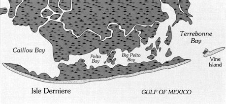
Last Island , also known as Isle Dernière, was a barrier island in far southern Louisiana. The island was home to a resort, hotel, casino, and about 100 summer homes, all of whom enjoyed the white sandy beaches and continuous breeze, making the island much cooler than mainland Louisiana. Map of Last Island as it appeared in 1853. In 1856, a major hurricane, known as the Last Island Hurricane , swept through the island, with a 13 foot storm surge (the elevation of the island was only 5 feet). Over 200 people were killed, and every structure on the island was destroyed.  Last Days of Last Island  delves further into the hurricane and its effect on the island. The Hurricane’s storm surge and subsequent erosion caused the island to split into two. Further storms, erosion, and climate change have contributed further to the former island’s demise, which is today five uninhabitable islands; East, Trinity, Whisky, Raccoon, and Wine Islands, each of which has disappeared and reappeared in recen

The Forgotten Railways of Chicago: Shedd Aquarium's Railroad Spur and Custom Railcar

Image
According to the 1929 USGS Jackson Park topo map, there was a spur line from the still-existing Illinois Central tracks west of Lake Shore Dr to the Field Museum . It went around Solider Field and where present-day Museum Campus Dr is today. By 1958, the line was no longer present on topo maps. But this line actually served another lakefront institution: the Shedd Aquarium. It is an open question as to whether any of the other buildings used it, although it would most certainly come in handy today to transport fans to/from Bears games. 1929 USGS Jackson Park Topo Map . And yes, it's Soldier Field , not Soldiers Field. This was a rail line used by the John G. Shedd Aquarium for their custom made Pullman car, The Nautilus , to transport fish and crew members. "You would have seen the Nautilus railroad car on temporary tracks next to the building if you’d attended Shedd’s opening ceremonies on May 30, 1930. It had just returned from Key West on a collecting trip for reef fishe