Posts

Showing posts from May, 2018

5 Abandoned Railroads (In Places You'd Never Expect)

Image
During the 19th Century, the railroad industry spread all across the world from its beginnings in the United Kingdom. The United States, Canada and Mexico all owe the industry greatly for developing their interior. Indeed, the American West would look a lot different today were it not for the railroad industry.  While large, intercontinental railroad lines make perfect sense, and are the backdrop for American lore, railroad have also been built all across the world, including many remote and obscure places. Here are some examples of railroads that have been built in extremely remote destinations. You can type in the GPS Coordinates into our Abandoned & Out-of-Service Railroad Lines Map and see these lines in greater detail for yourself! 1) " The Qoornoq X-press" - Qoornoq, Greenland (64.52932, -51.08905) With a population of about 56,000 people spread across a mostly frozen tundra, one wouldn't expect Greenland to have much, if any, railroads. That, f

The Forgotten Railways of Lake County, Illinois

Image
As the County immediately north of Cook County and the City of Chicago, as well as south of Milwaukee, and with Lake Michigan to its east, Lake County has a ton of railroad history, as many lines passed within its borders. To this day, the railroad industry remains an integral part of the county's transportation infrastructure, as four passenger lines run within the county, en route to Chicago. Map of McHenry and Lake County's Railroad System in 1854. Source: Illinois Digital Archives Today's blog will be a focus on the history of Lake County's railroads. Thanks to Metra  for providing some of these histories on their website. ACTIVE LINES: Railroad service came to Lake County in the 1850's. In 1854, the Chicago & Milwaukee Railway began operations between its namesake cities, and the Illinois & Wisconsin Railroad followed shortly after, running trains from Chicago to Janesville.  Both of these pioneering railroad companies are long gone;

The Abandoned Route 66 in McCook, IL

Image
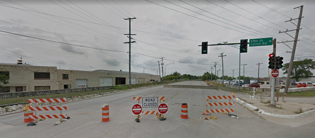
Route 66, the iconic "Main Street of America," weaves through the heart of the United States, connecting communities and embodying the spirit of adventure. However, not all sections of this historic highway have stood the test of time. While much of the former US 66 is drivable in one way or another, especially in Illinois, there are some parts are not.  One of the first such roadblocks for would-be travelers heading from Chicago to Los Angeles via the Mother Road, now known as Joliet Road, comes just outside of Chicago in McCook, IL, where the former highway is closed between 55th St and East Ave, and has been for over two decades. (Link to the location on our Ghost Towns Map ) Image: Google Maps at 55th and Joliet Rd in McCook, IL The land that the quarry would eventually take over was part of Stinson Airport in the early days of Route 66, dating back to before 1930. ( Abandoned Airports map ). 1938 USGS Aerial Imagery The quarrying on the south side of the road would

5 Historic Roads You Can No Longer Drive On

Image
I decided to take things off the rails with this blog and talk about roads. While all infrastructure needs to be updated over time, roads are rarely abandoned, unlike railroads. When a railroad line's existence can no longer be justified by its traffic volume, as a privately owned piece of infrastructure, it is sold off or liquidated, or abandoned. If the Main Street in your town is bypassed by a brand new six-lane freeway on the outskirts, it still serves a purpose to the townsfolk, and more importantly, is continuously funded by them. However, roads are not immune to abandonment either. Here are five roads you can no longer drive on today.  1) Abandoned Pennsylvania Turnpike (East of Breezewood, PA) Wikipedia Abandoned Pennsylvania Turnpike. Photo: Jgera5 Breezewood, PA is a strange little town when it comes to roads. It's home to one of the very  few traffic lights on an Interstate Highway, as to continue east on I-70 requires you to do a loop in Breezewood. East o

The High Line: A New York City Linear Park

Image
The High Line is a public park built on a historic elevated railway in New York City. It runs from Gansevoort Street in the Meatpacking District to 34th Street, near the Hudson Yards development. The High Line was originally built in the 1930s as a freight rail line to lift dangerous goods off the streets of Manhattan and into factories. A tree in bloom right in the middle of one of The High Line's rebuilt tracks, to show nature and its relationship to technology. It is one of the best known linear parks in the world. I was lucky enough to experience this New York City gem for myself during a weekend trip on Cinco de Mayo in 2018. Here are some photos, a little history, and my own opinions of the park. The High Line does an excellent job of keeping the history of the line preserved, and accessible for future generations to understand. After experiencing the park firsthand, I believe that The High Line raises the bar for rail trails across the country. While many trails