Posts

Showing posts from 2019

Ogden Avenue Once Had Four Numerical Designations. It Has Zero Today.

Image
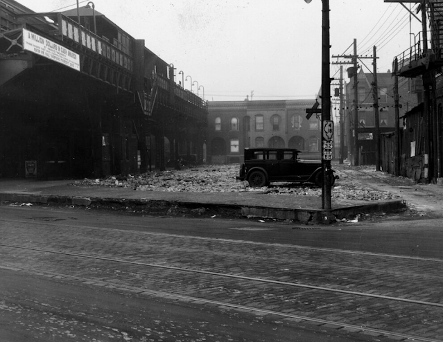
Sometimes a picture is worth a thousand words, at least when there's four highways labeled in a single frame, and none of them exist on this road today. Image: Chicago Transit Authority, 1930 via USEnds.com There is a lot that's forgotten here in this 1930 image of Ogden Ave in Chicago, IL, as the photo depicts two decommissioned US Highways, 32 and 66, and two Illinois state routes that still exist, but run nowhere near Chicago today. What was once signed with 4 different numerical designations is now an unnumbered road.  To make things even more confusing, Ogden Ave in much of the Chicago area is signed as US-34, which came a few years after this picture was taken. Today, we're going to quickly explore how each of these highways came to land on the same road, and why they no longer run on Ogden today. Ogden Ave is currently signed as US 34 west of IL-43/Harlem Ave in Berwyn, which is where US-34 presently begins .  Illinois Route 4 was a Chicago-St. Louis road that some

The Rockdale, Sandow & Southern Railroad

Image
The Rockdale, Sandow & Southern Railroad connects with the Union Pacific Railroad at Marjorie, TX, running about six miles south to a smelter at Alcoa, TX. Photo: Wes Carr  via TrainWeb.org In November 2019, its parent company Alcoa Energy Services filed a petition to abandon the line, citing no current demand for rail service and no apparent traffic prospects. In the filing, it leaves open the potential for part of the right of way to remain open disconnected from the rest of the US rail network, which would make the line not subject to STB regulation. The line has been in service since 1923, with common carrier service since 1952. The only real traffic came from the metals industry, as the line hauled mostly aluminium products. STB Website : Search for AB_1291_0_X

The Colorado Springs & Cripple Creek District Railway

Image
The Colorado Springs & Cripple Creek District Railway connected its namesake towns in Colorado, beginning in 1897, along a right of way over 38 miles in length. ( Right-of-way ) Image: Cathedral Park, Garden of the Gods, Colorado Springs, Colorado . "The train tracks belong to the Colorado Springs & Cripple Creek District Railway." Photochrom print by the Detroit Photographic Co. copyrighted 1901. From the Photochrom Prints Collection, Library of Congress. It was built during Colorado Springs' second gold rush during the 1890's, but faced competition from many of the other railroads built to tap into the mines at Cripple Creek. Despite the rugged terrain it ran through, it was a standard gauge line. Much of the rolling stock of the company, and other companies in the area, was left in the town of Cripple Creek , and were often incorporated into new buildings, or destroyed as time went on. An abandoned car turned building, c. 1960. FRRandP photo collection.

The Chicago West Pullman & Southern Railroad

Image
One of the many, many short line railroads that have existed within the City of Chicago was the Chicago, West Pullman & Southern Railroad , the brainchild of Cyrus McCormick in the 1880's. Paul Hunnell photo, 1984. FRRandP Photo Collection McCormick founded the International Harvester company, and wished to manufacture and produce the materials necessary for its products in house. To that end, he gained control of a steel company that became Wisconsin Steel on Chicago's South Side, and the CWP&S was constructed to transport materials between the two plants. Here's a map of the operations. Originally found from Industrial History. The company lasted until 1983, when the Chicago West Pullman company purchased the assets of the steel plant and railroad, and abandoning unnecessary trackage. What is left of the right of way is now part of Chicago Rail Link . Thanks as always for reading!

Choum Tunnel: The Monument to European Stupidity in Africa

Image
Scars of European colonization are located all across Africa, although some are more obscure and strange than others. With that in mind we come to the Choum Tunnel , built in Mauritania when it was controlled by the French. At first glance, it seems like an ordinary railway tunnel, however, one look at the local geography and you'll find yourself asking what its builders were possibly thinking with creating the project. Choum Tunnel in Mauritania. Unknown photographer. The Mauritania Railway was being built in the early 1960s, and was planned to connect Nouadhibou to Zouérat to exploit the iron ore reserves at Zouérat. That route still exists today in largely its original state, with the exception of the tunnel. Image: Ammar Hassan via Atlas Obscura The easiest route required running a short section of track through the then-Spanish controlled Western Sahara , but rather than pay Spain for the land and other concessions, the French engineers instead chose to tunnel under a hill sp

A Railroad Trestle at the Nevada Nuclear Test Site

Image
The Nevada Nuclear Test Site was one of many areas where nuclear weapons were tested in the United States, with the first one conducted on January 27th, 1951. It was located in Nye County, NV , and is still technically active today, albeit without nuclear weapons tests. A November 1951 image of a nuclear test. Public domain image.. Many tests were conducted on industrial and community buildings to study the effects of nuclear weapons detonations from various distances, both above-ground and below-ground. According to Atomic Heritage , "Underground nuclear testing began at the NTS with Operation Nougat in September of 1961.  Map of the Nevada Test Site from Origins of the Nevada Test Site The Armed Forces Special Weapons Project (AFSWP) originally planned underground tests to be conducted on the island of Amchitka off the coast of Alaska. This changed after the creation of NTS, when the AFSWP decided they wanted to test in Nevada in order to develop a more comprehensive map of fal

The Kaslo & Slocam Railway

Image
The Kaslo & Slocan Railway began service in 1895, running between Kaslo, BC, and the mining community of Sandon in the Kootenay region of British Columbia, Canada. ( Right of way ) Image: Payne Bluff above Sandon on the Kaslo and Slocan Railway (BC Archives) Like most mountainous railroads, it ran a narrow gauge route, and competed with the Canadian Pacific Railway-owned Nakusp & Slocan Railway throughout its life for access to the silver mines in the area. 1908 would be the last year of independence for this line, as expensive repairs were needed after spring flooding.  CP would lease the line in perpetuity and merge it with the N&S Railway in 1911. While it initially was profitable during World War I, traffic slowly dwindled, until CP finally abandoned the line in 1955. Further Reading:  The Skyline Limited: The Kaslo and Slocan Railway ( Amazon ) Thanks as always for reading!

The Transandine Railway

Image
The Transandine Railway connected Argentina and Chile over the Andes Mountains, running between Mendoza, Argentina and Santa Rosa de los Andes in Chile, along a 154 mile route. ( Right of way ) Image: Umatilla Station, Public Domain It opened in 1910, and in doing so, cut travel time from Valparaiso, Chile to Buenos Aires, Argentina from 11 days to just 36 hours. Map of the line. Despite the engineering marvel , the railway was never a commercial success, and as such, east of Rio Blanco, Chile, the line has been closed and dismantled since 1984, although proposals still remain to reopen the line. Thanks as always for reading!

The Unbuilt City Planned By, and For, Alcoholics

Image
Have you ever felt as though society should be built around alcohol? By that I mean not simply allowing unfettered access to the commodity, but build an actual city around drinking as much as humanly possible? Hold onto your livers, because somebody actually proposed such a city. I first heard about this from a Cracked article, and while anyone can propose a crazy city, its promoter actually came somewhat close to making his alcohol-fueled dream a reality. BoozeTown was a city proposal by a man named Mel Johnson during the 1950's, who yearned for a city where alcohol would be available in bars 24 hours a day. This was in a time before Las Vegas and other cities had all-night bars and drinking available. This fits perfectly into the Fallout universe somehow. "At first Mel was going to plan BoozeTown out with straight north/south and east/west roads, but he realized from his time in the old cities that the random layout of those cities was why they were so fun. Getting lost le

Riverton, Alabama, a Damming Casualty (And the Railroad that Served It)

Image
Once located in the far northwestern corner of Alabama , the townsite of Riverton on the Tennessee River is now underwater, after the construction of the Riverton Lock , which began in 1895 and was fully completed in 1911. The first major upstream landing on the Tennessee River was Riverton, a former town site in Colbert County, Alabama. Riverton was located on the east side of the junction of the Tennessee River and Bear Creek, across Bear Creek from Eastport. Colbert and Bee Tree Shoals were immediately up river from Riverton and prevented major river traffic between Riverton and Florence, Alabama, for six months of the dry season. Before the town was inundated however, a branch of the Birmingham Sheffield and Tennessee River Railway , which later became the Northern Alabama Railroad, ran between Margerum and Riverton. Despite being a branch of the Northern Alabama, the Riverton Branch only connected to the rest of the route via the Memphis & Charleston Railroad, which later be

Long Island Rail Road's Abandoned Cedarhurst Cut-Off

Image
The Cedarhurst Cut-off is one of the abandoned branches of the Long Island Railroad . Incorporated as the New York and Rockaway Railroad  in 1871, the abandoned section began near present day Laurelton Station and continued south in between Lansing and Edgewood Aves, crossing a bridge at North Woodmere Park, continuing down to Cedarhurst. The branch has been abandoned and rebuilt twice, creating a rather complicated history of the relatively obscure line. It was first abandoned after the LIRR took control in 1876, it was rebuilt in 1905, but was never put into revenue service and instead was only used to route equipment.  Thirteen years later, it was abandoned again in 1918. It was rebuilt yet again in 1928 as a LIRR ploy to protect their right-of-way from development, but the branch was nonetheless considered redundant, and it was abandoned for good in 1934. Despite not having a revenue train in the last 100 years, and not any development since before World War II, there are still sm

The Cemetery Next to a Particle Accelerator: St. Patrick Cemetery

Image
In the early 1950's, at the height of new discoveries in nuclear energy, Argonne National Laboratory had outgrown its original campus at the University of Chicago , as well as the forest where it had conducted other experiments during the late 1940's, where currently the world's first nuclear reactor remains buried today . The site chosen would be on 3,500 acres in unincorporated Downers Grove Township in DuPage County, IL. What was once farmland would be converted into space to develop energy, weapons, and other Cold War inventions designed to keep the United States as the premier superpower in all things technology. However, two of those acres held cemetery land owned by a nearby church, St. Patrick's Catholic Church in Lemont, IL. The decision was made to keep the cemetery in its original location, as opposed to relocating it to accommodate the laboratory. As such, it is impossible to travel to this cemetery by vehicle, but you can walk along the former Bluff R

The Nevada Short Line Railway

Image
The Nevada Short Line Railway was the last independent short line railroad to run in the State, beginning service in 1913. ( Right of way ) The line connected Oreana, NV with the silver mines at Rochester, NV along a 12.5 mile route. The line came near, but did not connect to, the Southern Pacific at Oreana, as it was a narrow gauge line. The railway did not last long enough to convert to standard gauge, although was planned to do so. Image and History Like many independent short lines across the US, the NSL did not last long. Floods, lack of equipment, inadequate freight, and insufficient funds doomed the railway. It was scrapped in 1920, after having last operated in 1918. Thanks as always for reading!

The Unbuilt Southern New England Railway

Image
The Southern New England  Railway was an incomplete railroad proposal to connect Palmer, MA with Providence, RI, first chartered in 1910. The line would've been owned by the Grand Trunk Railway to compete with the New York New Haven & Hartford Railroad in the area. To be competitive, the line would have much smoother grades, and more bridges over valleys, to create the shortest route feasible through the area. Right of way of the unbuilt railway in red. Wikipedia Commons . Construction began in 1912, but stopped shortly thereafter due to worldwide economic conditions. By 1916, grading in Massachusetts was complete, but expansion of the line into Rhode Island had been postponed. Although World War I occurred during this time, it was not the ultimate cause for the line's failure. The Grand Trunk Pacific (a GT subsidiary) was bankrupt during this time, and the GT itself was to be amalgamated into the Canadian National Railway system, who wished to focus more on Canadian rai

The Indian Creek Valley Railroad

Image
The Indian Creek Valley Railroad ran along Indian Creek in Pennsylvania, beginning at a junction with the B&O Railroad , and running 22 miles northeast starting in 1910. The junction was aptly-named as "Indian Creek". ( Right of way ) While its primary haul was timber, like many Pennsylvania railroad lines, it hauled coal as well, in addition to passenger trains. Towns along the route included Jones Mills, Indian Head, Melcroft, and Champion, PA. Image and History By 1926, the right of way would became part of the B&O, who would abandon the line in 1969 after timber and coal movements became too unprofitable for the line to remain. Today, two sections of the right of way are rail trails , with a connection between the two sections planned for the future. Thanks as always for reading!

The Unsigned Interstate Highways

Image
Despite being the highest standard of highway in the world, the Interstate Highway System has a few highways which, despite being fully part of the system, do not carry such a signed designation. This mirrors Illinois' Unmarked  Highway System, although there are far fewer unsigned Interstates. Image" I-296 acknowledged on a 1978 Michigan Map. I-296 is the "hidden" designation for US-131 between I-96 an I-196 in Grand Rapids. ( Interstate-Guide.com ) Since I began learning about the Interstate System in my youth, the fact that there existed "hidden" Interstates fascinated me. Today we'll go over some of these routes, and why they aren't signed as an Interstate. Alaska & Puerto Rico: The Interstate Highway System at its inception was much different than it is today, with regard to funding. During the initial construction of the system, 90% of the funds for the roads were provided by the Federal Government. Most Interstate highway projects to

Magilligan Point's Abandoned Railway

Image
Magilligan Point is located on the Northern coast of Northern Ireland, across from Greencastle in Ireland, which it connects to via ferry. The nearest railway line is about four miles south at Magilligan. Image: Discover Northern Ireland But it wasn't always that way. A f our mile branch line to connect to the ferry was built and opened in July 1855 by the Londonderry and Coleraine Railway . This branch was only served by horse power , not steam, however. ( Right of way ) This line would be one of the first to close on the entire island of Ireland, as just three months later, in October 1855, the line fell into disrepair, and would be abandoned. At least one proposal for reopening the line would come many decades later near the turn of the century by the Midland Railway, a successor to the Northern Counties Railway, of which the L&C eventually became part of. It did not materialize, and Magilligan Point has thus not been served by rail in over 160 years. During this time, the