Posts

Egypt's El Ferdan Railway Bridge - A Restored Transcontinental Railroad (Updated January 2026)

Image
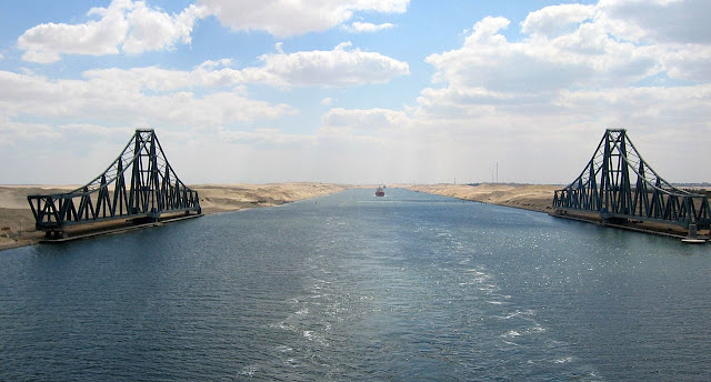
In the context of railway infrastructure, "Transcontinental" typically refers to the original Transcontinental Railroad , particularly in the United States. But very few pieces of infrastructure can truly be considered transcontinental.  One that can be considered is Egypt's El Ferdan Railway Bridge  ( Google Maps ), which is a dual swing bridge that spans the Suez Canal , connecting Africa with Asia. The bridge opened in 2001, and is (or was) the longest swing bridge in the world. Between 2001-2015, it served the Egyptian National Railway . Between 2015 and 2024, it was out of service, partly due to the Suez Canal's reconstruction and expansion, but was reactivated and expanded in late 2024 to once again reopen. This blog was originally posted in between that time frame, so context has been added to reflect the fact that it is now once again in service. Railway bridges over the Suez Canal have had a tendency to not last very long, as it was the fifth bridge over the ...

The Dodge City Montezuma & Trinidad Railway

Image
The Dodge City Montezuma & Trinidad Railway was a short-lived railroad operating between Dodge City and Montezuma, KS. ( Right of Way )  Looking at a modern rail map of southwest Kansas, one might reasonably assume that Dodge City and Montezuma have always been connected by the same railroad. After all, the two towns remain linked by rail today.  Photo: City of Montezuma, KS But this apparent continuity hides a short-lived and politically motivated predecessor: the Dodge City, Montezuma & Trinidad Railway; a railroad whose entire existence was born out of a county seat dispute and whose abandonment reshaped the geography of Gray County. Original alignment. The Montezuma we know today was not the original town to bear that name. The present-day community was platted by the Atchison, Topeka & Santa Fe Railway in 1912, nearly twenty years after the first Montezuma had already faded into obscurity. That original town, now a ghost town, briefly flourished thanks ...

Why H.R. 4924 Threatens the Spirit of the Rails-to-Trails Movement

Image
I try my best on this blog to stay out of current political matters and almost always stay out of social issues. That said, I cannot stay about the threats to the rails to trails movement as we know it. Across the United States, there are old rail corridors that never quite disappeared. We have visited many of them on this blog: lines where rusted steel and weed-choked ballast once marked an ending, now quietly repurposed into trails filled with movement and life. These are the rail-trails , places where locomotives once thundered and where today you are more likely to hear conversation, bicycle chains, or the crunch of gravel underfoot. They have become connective tissue for places long left on the margins, stitching together urban neighborhoods, suburban downtowns, and rural villages that lost their rail service generations ago. In doing so, they have offered something rare in modern infrastructure: a second chance at connection, memory, and renewal. Walking the Wabash Railroad Righ...

The Cemetery in a Roundabout: Harrison-Harrell Cemetery.

Image
At first glance, there is nothing remarkable about Roy Hoppy Hopkins Drive. It cuts a clean arc through southern De Soto Parish, Louisiana, serving industrial traffic that moves between the parish’s plants and the industrial park. Or at least, it would if there was any actual activity in the Ward II Industrial Park , which as of late 2025, appears completely barren. Yet this road surrounds a much more interesting and historic place; quietly fenced and immovable, lies a small cemetery that predates the road that now encircles it. As is the genesis of many of my discoveries, I came across a cemetery located in the middle of a roundabout while looking somewhat-aimlessly at Google Maps: Harrison-Harrell Cemetery on our Abandoned Cemeteries Map This roadway is part of an industrial/logistics corridor that was constructed in the early 2000's according to aerial imagery. The cemetery was only accessible via LA 170 to the east before Hopkins Dr was both extended and improved to connect to ...

Well We’re Living Here in Oniontown

Image
Tucked off a narrow, unpaved dead-end road just south of the hamlet of Dover Plains in Dutchess County, New York , lies a place that seems suspended in time, and drenched in myth. That place is Oniontown . Despite being only roughly 1½ hours by car from the bright lights of New York City , it sits in what feels like a remote no-man’s-land of folklore, suspicion, and social neglect.  Richard Wilcox Home, 1947 . Getty Images Having recently driven through the Hudson Valley between New York and Boston, the area that I'd first heard about from Atlas Obscura came to mind again, especially with how rich of an area I drove through in comparison to the zeitgeist surrounding Oniontown. If you imagine a more neglected corner of the Hudson Valley where the trees close in, the pavement ends, and a single strip of gravel leads you toward the woods, well your imagination is going to be pretty close to Oniontown. The paved road ends, and beyond it you’ll find trailers, modest ranch-style house...

Beneath the Pavement: Hidden History in Cook County’s Parcel Fabric

Image
If you zoom far enough into Cook County’s parcel data , you’ll find something strange. Beneath the steady roar of the Eisenhower Expressway (I-290) under the lanes of traffic, the CTA Blue Line tracks, and the median embankments, lies a full grid of property parcels. Every one has a unique PIN, neat cyan lines drawn as though the houses, alleys, and corner lots were still there. To the eye, it’s all concrete. If you were only looking at the parcel fabric and not an aerial below it, you could be forgiven for thinking that it’s still a neighborhood. Rather, it is all that is left of the neighborhoods that were destroyed to create the Eisenhower, and these parcels exist for all of the Chicago area expressways. Cookviewer Image of Active Parcels as of 2024, even though none of these parcels have had any separate land uses since the Ike. Cook County’s parcel fabric is a digital layer that represents the county’s property boundaries, as an enormous and constantly updated spatial dataset that...

The Hanford Site

Image
The Hanford Site , also referred to as Hanford Engineer Works or Site W, is a decommissioned nuclear production complex located along the Columbia River in Benton County, Washington. Established in 1943, it was a secret facility of the Manhattan Project , selected for its abundant river water, hydroelectric power, mild climate, strong transport links, and remote location. Image: United States Department of Energy - Image N1D0069267., "Nuclear reactors line the riverbank at the Hanford Site along the Columbia River in January 1960. The N Reactor is in the foreground, with the twin KE and KW Reactors in the immediate background. The historic B Reactor , the world's first plutonium production reactor, is visible in the distance." Construction began in 1943, and by September 1944, the B Reactor became operational , making it the world's first full-scale industrial plutonium reactor. This reactor supplied plutonium for the Trinity Test and for the “ Fat Man ” bomb dropped...