The Milwaukee Road "Frying Pan" in Beaver Dam, Wisconsin
The Frying Pan Line was a spur line built by the Milwaukee Road to serve downtown Beaver Dam, WI. As it was a loop line that served the downtown area of Beaver Dam, it was given the "Frying Pan" nickname.
It was less than two miles in length from Beaver Dam Jct. on the mainline to the loop downtown, and thus is an interesting little spur line perfect for discussion from us.
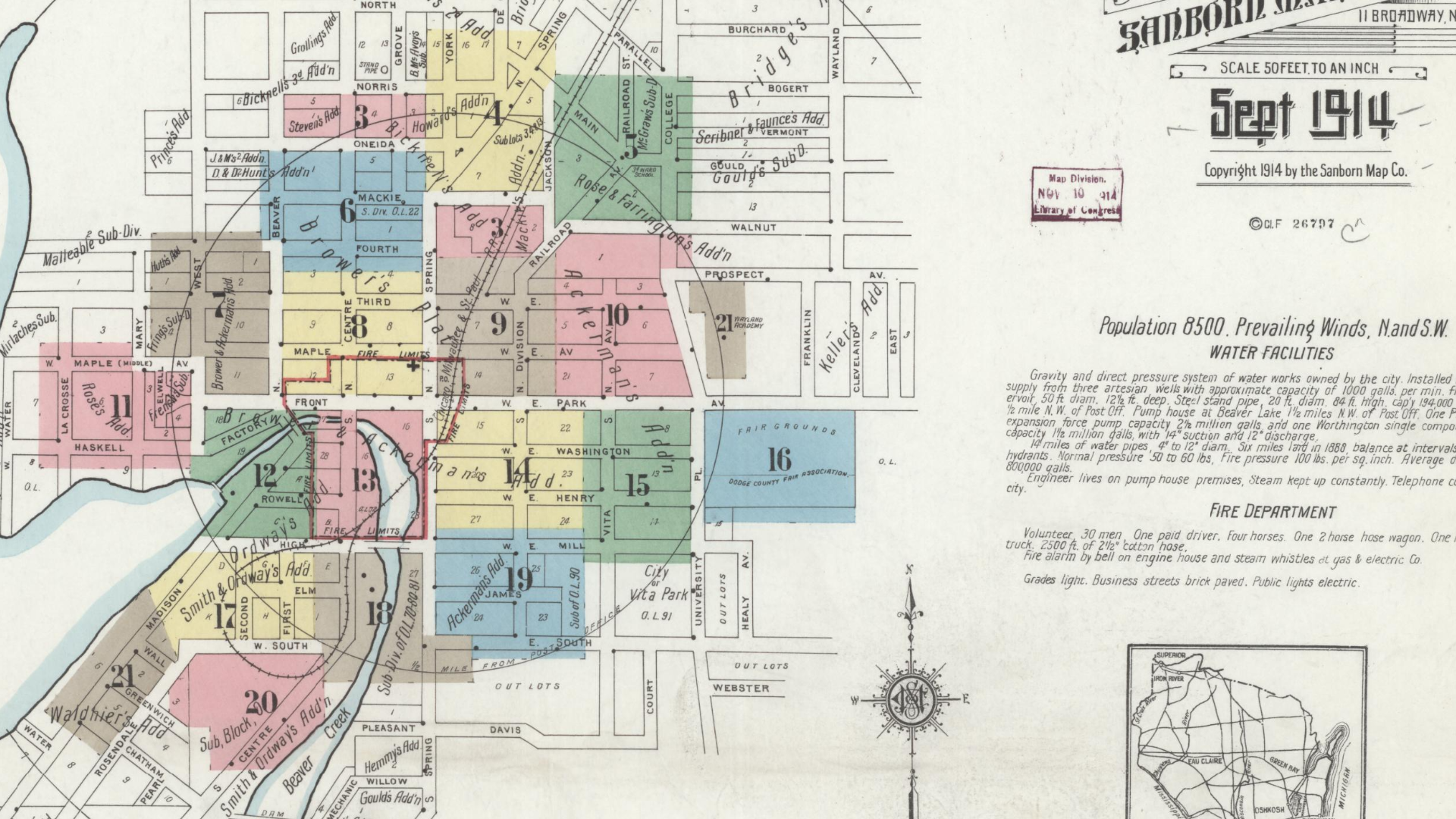 |
| Beaver Dam on the 1914 Sanborn Map, with the majority of the Frying Pan line visible. (Library of Congress) |
It was built late in 1882, and used some of the right of way of the never built Beaver Dam & Baraboo Railroad, which was an early ancestor of the Milwaukee Road. The Milwaukee constructed a line northwest of Beaver Dam as opposed to heading south and west towards Baraboo, and thus the "Frying Pan" served the Beaver Dam manufacturing concerns, while the mainline bypassed the majority of the town.
 |
| Fact on the "Frying Pan" line from Beaver Dam's 175th Anniversary Brochure |
 |
| Beaver Dam Depot on the Frying Pan Line, 1908. Postcard mage via Bob Cozby. |
WiscNews interviewed a local historian named Patrick Lutz regarding the line, “The Frying Pan was put in place to serve the businesses that were originally established in the heart of the city,” Lutz said. “The Milwaukee Road railroad line came to Beaver Dam in 1856 and originally stopped at the edge of the city, just north of where University Avenue meets North Spring Street.” (WiscNews)
 |
| Another view of the depot, this one from 1916. Postcard image via Bob Cozby. |
The Malleable Range Company was founded in 1896 and became one of, if not the first, examples of manufacturing that the Frying Pan line served.
The line, like all abandoned lines that we've found thus far, is on our abandoned railroads map, but Joe S provided us with far greater detail than we could have added to the map about different sidings and spurs from the line, so we created a separate map strictly for this line!
Joe's map shows all of the manufacturing and areas that the Frying Pan served, and it's a great example of how railroading served the economy and provided the transportation necessary to keep the country moving before automobile traffic.
The Milwaukee Road Project on Flickr has provided numerous aerials and photos of this line and many more associated with the much larger Milwaukee Road.
 |
| 1980 Aerial Image of the Frying Pan Line in Beaver Dam. (Milwaukee Road Project) |
Another 1980 Aerial shows the Wye of the Frying Pan with amazing detail:
 |
| 1980 Aerial Image of the Frying Pan Line in Beaver Dam. (Milwaukee Road Project) |
The line was abandoned in the early 1990's, after the on-line customers moved to trucking or relocated away from Beaver Dam, but there is still a remnant of the former line, a caboose outside of the Dodge County Historical Museum:
 |
| Milwaukee Road Caboose 992195. Image: Dodge County Historical Society |
The museum elaborated, "In 2003, a group of railroad enthusiasts gathered to discuss the possibility of purchasing an actual caboose to be placed on display in the city. The location would be on the original railroad bed of the Milwaukee Road, which passed through the city. This line passed by the buildings, which now house the Dodge County Historical Society and the Beaver Dam Chamber of Commerce, which was originally the passenger depot for the Milwaukee Railroad."
As this line has some connective tissue to the unbuilt Beaver Dam & Baraboo Railroad, that will be the subject of our next blog, coming soon!
Thanks as always for reading!


Comments
Post a Comment