Posts

Showing posts with the label Michigan

The Chicago Kalamazoo & Saginaw Railway

Image
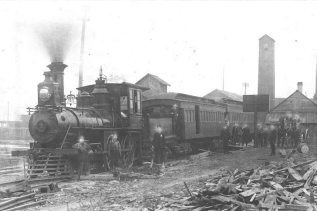
The Chicago Kalamazoo & Saginaw Railway was a railroad operating almost entirely within Kalamazoo County, MI, between Kalamazoo and Hastings, MI, constructed in 1883. ( Abandoned Right of Way ) It would further connect to Woodbury, MI and the Pere Marquette Railway. An informal nickname for the road was the Cuss, Kick & Swear. CK&S Locomotive at Pavilion, MI. The CK&S Railway was not designed to connect to Chicago, as the name might suggest, but it also did not connect with Saginaw either. More grandiose plans for the line came in 1887, as the company amended its articles to construct a northeasterly extension towards Saginaw, where it would connect with the Chicago and Grand Trunk Railway, but this ultimately never came to fruition.  The construction began in 1883, and the railway made its way almost entirely within Kalamazoo County, reaching as far as Hastings, MI. However, the line fell short of its intended destination, stopping only 14 miles past Hastings...

The St. Clair River Pontiac & Jackson Railroad: An Unbuilt Mystery

Image
For the better part of the last year, I've been stuck trying to figure out what appeared to be the trace of an abandoned rail line immediately west of Pinckney, MI, which is easily visible in the satellite imagery below. Google Maps image of the line west of Pinckney via our Abandoned & Out-of-Service Railroad Lines map . The line in question diverges from the right of way of the former Grand Trunk Railway line that is now part of the Lakelands Trail . The grading is fairly consistent for the first 10 miles of line, and then just stops around the Joslin Lake area, which led me to believe that it was either a long-forgotten ice house spur, just like the California Ice and Coal Company Line in Antioch, IL, or a logging railroad of some kind, of which numerous operated in the State of Michigan, albeit usually in the northern part of the Lower Peninsula. However, after being unable to find any information corroborating those theories, I finally came across what appears to be the R...

The Telegraph Rd Behind Dire Straits' "Telegraph Road"

Image
"And the dirty ole' track...was the Telegraph Road"...the first time I heard those lyrics, I knew I was listening to one of the most incredible songs I'd ever heard. To find out it was based on an actual  Telegraph Rd was just the icing on the cake. Before the creation of Interstate 75, The major thoroughfare between Toledo and Detroit was Telegraph Road . Currently carrying US Highway 24, Telegraph Road was immortalized as a song by Dire Straits in their 1982 album "Love Over Gold".  Early travel brochure for US-24, showing its importance as a road one could use between Los Angeles and Quebec; although it only ran from Michigan to Colorado. If you have 14 minutes to spare, the song is an awesome bit of 80's progressive rock. Today we're going to do things slightly different, in that I was to discuss the history of both the road and the song, because I think the lyrics do a great job to that end. The modern-day Telegraph Road is one of the major par...

The Mystery of the Niles & Buchanan Railway

Image
The Niles & Buchanan Railway, mapped below in white, was a proposed, but evidently unbuilt interurban railway between the namesake towns in southern Michigan. Interurbans at the turn of the 20th century, and for a few decades following, were all the rage in railroad construction in the United States, and connected small towns with small cities, and through various disconnected systems, one could even travel regionally.  However, they were not at all profitable, and this was before many of them were purchased by auto manufacturers , who had an obvious vested interest in converting many of those systems to buses. As such, the holistic view of the interurban is a curious piece of railroad history, but to say it changed the industry in any lasting way is a stance hard to defend; they were both predated and outlasted by most steam railways. From our Abandoned & Out-of-Service Railroad Lines Map There were also numerous interurbans that were never fully completed, as was the case...

The Wisconsin & Michigan Railway

Image
The Wisconsin & Michigan Railway was the 1893 brainchild of John N Faithorn, A Chicago railroad tycoon with financial backing to build a road that would connect the iron-rich Upper Peninsula of Michigan, with the steel mills in Chicago and other Great Lakes cities, using both railroads and car ferries. ( Right-of-Way ) Image: "Employees of the Wisconsin and Michigan Railway at the Round House in Peshtigo Wisconsin." In spite of the global Panic of 1893 , funding from John Bagley among others meant construction began on the line, regauging the Ingalls White Rapids & Northern Railroad to standard gauge to incorporate into the new right of way. Eventually the line connected Iron Mountain, MI with Peshtigo, WI, using surplus rail from the 1893 Chicago World's Fair, and with trackage rights on the Milwaukee Road at Marinette, WI would have ferry access, which began in 1895. In 1908, the railroad reached its maximum size, with a few branch lines primarily used for log...

How Michigan and Ohio Got Part of Their Shapes: The Toledo War

Image
The Toledo War was a boundary dispute between the State of Ohio and Michigan Territory over the area known as the " Toledo Strip ". It emanated from a poor understanding of the location of the Great Lakes, and vague interpretations of the border between Ohio and Michigan. The area shaded in pink is the land in question. Image: Map by David Burr from U.S. House Report 380, 24th Congress, 1st Session, highlighting the contested land area between Michigan and Ohio territories ( Wikipedia Commons ) The placement of the State Boundary would determine whether the City of Toledo, and thus its Port, would lie in the State of Ohio, or in Michigan Territory. When Congress passed the Enabling Act of 1802, which authorized Ohio to begin the process of becoming a U.S. state, the language defining Ohio's northern boundary differed slightly from that used in the Northwest Ordinance: the border was to be "an east and west line drawn through the southerly extreme of Lake Michigan, r...

The Boyne City Gaylord & Alpena Railroad

Image
Boyne City, MI's railroad operations began in 1893 with the creation of the Boyne City Southeastern Railroad , running 7 miles east to Boyne Falls. The line was owned by the W.H. White Lumber Company to tap into northern Michigan's logging industry. Image: Detroit Public Library In 1905, the Boyne City Gaylord & Alpena Railroad  was chartered to succeed the line and extend it to Alpena, MI, 91 miles east of Boyne City. ( Right-of-Way ) Image: Railroad Michigan While expansion took longer than expected, the railroad finally reached Alpena in 1918. Included in the expansion were three branch lines, each of which was used to expand the WH White Lumber Company's land holdings. The land was purchased, cut down, and then marketed to farmers once cleared, who would then benefit from having the BC G & A as a transportation system to the rest of the US railroad network. Unfortunately, Michigan's short growing season, and the lack of fertile soils along ...

US Highway 112

Image
US Highway 112 originally connected Detroit, MI with Elkhart, IN, starting in 1926, along with the rest of the original US Highways.  In 1932, it moved farther west, connecting Detroit with Rolling Prairie, IN. In 1936, its final routing was established, running between New Buffalo, MI and Detroit, thus remaining entirely within Michigan. The Indiana portion of the ex-US-112 was briefly known as US-112S .  Michael Summa Simulated 112 Shield via USEnds The route ran south of its parent US-12, but along a similar route, as both roads ended in Detroit. The road had its origins as part of the Sauk Trail between Chicago and Detroit, and would be the primary method of connecting the two major cities, until the Interstate Highway System came into existence.  Entire Sauk Trail- From  Chicago’s highways, old and new, from Indian trail to motor road - 1923 As part of this, US 12 was upgraded to freeway standards beginning in the 1950's, in anticipation of becoming Interstat...

The Traverse City Leelanau and Manistique Railroad

Image
The Traverse City Leelanau and Manistique Railroad was a railroad line built by the Grand Rapids & Indiana Railroad to built north from Traverse City, MI. Service ran north to Northport, MI beginning in 1901, and via a railcar ferry over Lake Michigan, connected to Manistique in Michigan's Upper Peninsula, with ferry service starting two years later in 1903. The ferry used a ship known as the Manistique for its journey between Northport and its namesake city. Sutton's Bay Depot, c.1920. Image via ExploreVistas In January, 1908, the Manistique sank in the harbor. It was temporarily replaced by an Ann Arbor car ferry but the ferry operation was discontinued in 1908. (Michigan Railroads) A picture of the Manistique Ferry. Image: Michigan Railroads In 1919, the line was reorganized as the Manistee & Northeastern Railroad , which served passenger and freight operations until 1955, when those were assumed by the Chesapeake & Ohio. Freight service declined...

Highways Over The Water - US 9 and US 10

Image
There are two highways in the US,  US-9 and US-10 , which have ferries that traverse waterways that would otherwise be considered gaps in their routes.  US-9, a prominent U.S. highway, had a peculiar gap in its route until 1964. It used to terminate at Lafayette Street in Cape May, New Jersey, facing the imposing Delaware Bay, making it appear as though the road just ended abruptly. The gap was eventually bridged with the introduction of the  Cape May–Lewes Ferry  service in 1964. This ferry enabled US-9 to continue its journey, now running through Delaware, from Lewes to Laurel, where it meets US-13. Image: Corco Highways US-10 was considered to have a gap in it until 2015, when the Historic SS Badger Ferry was officially codified into the route, traversing Lake Michigan between Ludington, MI and Manitowoc, WI.  The complexities of US geography are to blame for these gaps, as well as a land gap of US 2. Though, in the original 1925 plan of the US Highway syst...

The Marquette and Huron Mountain Railroad

Image
The Marquette & Huron Mountain Railroad was a heritage railway line that ran along the ex- Big Bay Branch of the Lake Superior & Ishpeming Railroad between Marquette and Big Bay, MI, starting operations in 1962, once freight hauls along the branch ceased. ( Right of way )   Marquette & Huron Mountain Steam Engine no. 23 in 1964. FRRandP Photo Collection (unknown photographer) The right of way began as the Marquette & Southeastern Railroad, which was merged into the Munising Marquette and Southeastern Railway in 1911 via a consolidation with the Munising Railway. In 1923, a much larger operation, the Lake Superior and Ishpeming Railroad took over operations. The route mainly handled lumber during its life before the heritage line took over, and as supply dwindled during the 1940's-50's, so did revenue. By 1962, the line was slated for abandonment before the M&HM Railroad was formed to operate the line as a heritage railway. Another shot of M&HM 23, fr...

A Visit to the New Buffalo Railroad Museum

Image
Today the Mrs. and I visited the New Buffalo Railroad Museum, a replica Pere Marquette Depot in New Buffalo, MI. The Depot is located near where the original PM station was for New Buffalo.  From the exterior, the grounds appear unkempt, and the parking lot needs work. Looks are deceiving though. This was one of the smaller railroad museums I've visited, although I highly enjoyed the little time I did spend there. There may not be any heritage operations running out of here, but they did pack a lot of history into a small space, and the potential for further renovation is quite easily visible. Adjacent to the museum is the former roundhouse used by the Pere Marquette, which was in service until 1984. The roundhouse, and its relocated turntable served none other than Pere Marquette 1225, made famous in the book and film adaptation of The Polar Express . Back of the roundhouse. Currently abandoned, it would be an amazing restoration project. A brewery perhaps? Imag...

The Manistee & North Eastern Railroad

Image
The Manistee & North Eastern Railroad was a short-line railroad operating in the northern Lower Michigan peninsula between Traverse City and Manistee, MI. Image: " Manistee & Northeastern engine No. 2 and the two coaches which inaugurated passenger service from this Buckley and Douglas mill site on January 6, 1889." (Manistee News) Additionally, the line had several branches, most notably from the mainline to Platte River Jct. (abandoned 1924) and Lake Leelanu, MI (abandoned 1944). It was incorporated in 1887, with the first operations beginning in January of 1889. At its peak, the mainline was over 62 miles in length. ( Right of Way ) Via the Leelanau Transit Company , it also traveled north to Northport, MI. Map of the M&NE Railroad and Branches, 1933. Via TrainWeb Like most of the rail lines in the region, it was built primarily to haul timber, but also carried passengers and other commodities. It was consolidated into the Chesapeake & Ohio in 1955, wit...