Posts

Showing posts with the label islands

The East Moline & Campbell's Island Railway

Image
Campbell's Island is located on the Illinois side of the Mississippi River across from Bettendorf, IA. It has the distinction of being the westernmost battle site of the War of 1812.  "Campbell's Island State Memorial is a granite monument that marks the site of a day-long battle on July 19, 1814 during the War of 1812 on Campbell's Island, Illinois." (Enjoy Illinois) The memorial was built in the first decade of the 20th century, at a time of significant building on the island. In 1901, an interurban railway known as the Moline, East Moline & Watertown Railway was incorporated along a six mile line to serve the three cities. Today, Watertown is part of of East Moline, IL, but got its start as a stop on the Milwaukee Road north and east of Moline. A year after incorporation, the company proposed to build up the island as a resort, purchasing the entire island the following year. "After the Moline, East Moline & Watertown Railway Co. bought the island...

Canada's Southernmost Point, Middle Island in Lake Erie

Image
Located at roughly 41.7 degrees north latitude, Middle Island  is the southernmost land point in all of Canada, about 164 yards from the Lake Erie Maritime border with the US State of Ohio.  1955 photo of the  Lighthouse on Middle Island . Ronnie Beatty, courtesy Bruce Beatty On a clear day, it, along with many of the other islands in the Lake Erie archipelago in both the US and Canada (especially Pelee Island ), can be seen from the top of Magnum XL-200 at Cedar Point .  It's nearly impossible to see in the POV, I suggest go visiting it yourself!  Middle Island's latitude means that it is slightly farther south than many parts of the US, and a majority of US States (27/50) have territory above 41.7 degrees north, including California, Nevada, and Utah, which end at the 42nd parallel. It's also slightly farther south than Downtown Chicago, and the entire State of Michigan. While the island is uninhabited today, archaeological study of the island indic...

Pearl Harbor Day and the Oahu Railway & Land Company

Image
In remembrance of Pearl Harbor Day , where in 1941 thousands of American military members perished in a surprise attack, we will discuss the construction of the Harbor, in which the US Navy Railroad used narrow gauge railroad lines to both build and maintain the harbor, ship repairs, and transportation in and around the complex. Construction began in 1909. At one point, the Oahu Railway & Land Company ran within Pearl Harbor, but a spur track was installed in 1920 allowing cars between the two railroads to interchange outside of the base. More information can be found here : 

Underwater Twice a Day: The Passage du Gois

Image
The Passage du Gois is a road that connects the Island of Noirmoutier with mainland France. It is 2.5 miles long. What makes the road noteworthy is that it is flooded twice a day by high tide. It is only passable for a few hours each day during low tide, and many drivers have had to be rescued from the road due to flooding. ( Google Maps link ) Nonetheless, The Passage du Gois has a rich history and has been in use for centuries as a means of accessing the island. The Passage du Gois during a daily flood. The road itself is still in service, but has been practically replaced by the Pont du Noirmoutier (Noirmoutier Bridge) on the southern part of the island as a means to drive back and forth without having to worry about the tides. Still, it is a popular tourist destination, attracting visitors from all over the world who come to see the unique natural phenomenon and to explore the island. Visitors to the Passage du Gois can take guided tours of the causeway, explore the island, and ...

Last Island, Louisiana: A Climate Change Casualty

Image
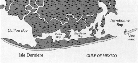
Last Island , also known as Isle Dernière, was a barrier island in far southern Louisiana. The island was home to a resort, hotel, casino, and about 100 summer homes, all of whom enjoyed the white sandy beaches and continuous breeze, making the island much cooler than mainland Louisiana. Map of Last Island as it appeared in 1853. In 1856, a major hurricane, known as the Last Island Hurricane , swept through the island, with a 13 foot storm surge (the elevation of the island was only 5 feet). Over 200 people were killed, and every structure on the island was destroyed.  Last Days of Last Island  delves further into the hurricane and its effect on the island. The Hurricane’s storm surge and subsequent erosion caused the island to split into two. Further storms, erosion, and climate change have contributed further to the former island’s demise, which is today five uninhabitable islands; East, Trinity, Whisky, Raccoon, and Wine Islands, each of which has disappeared and reappeared...

The Forgotten Railways of Hawaii

Image
Railways may not be the first thing you think of when it comes to the "Aloha" State, but indeed the island is still home to a couple small railroads. Oahu Railway & Land Company Locomotive 85, Oahu Railway & Land Company 4-6-0 #85, now on display at the Hawaiian Railway Society on Oahu. Historically, the Hawaiian archipelago was actually home to many railroads , and at least one ran on each of the main Hawaiian Islands. In today's blog, we'll explore some of these railroads. Island of Hawai'i The Island of Hawai'i, otherwise known as the Big Island, was home to the only standard gauge railroad in the future State of Hawaii, the Hilo Railroad, which later reorganized as the Hawaii Consolidated Railway. A story map tells the story of the railroad much better, and more in depth, than I ever could. Map of Hilo, HI, showing the route of the Hawaii Consolidated Railway. Source: University of Wisconsin-Milwaukee The mainline of the HC...

Martha’s Vineyard Railroad: A Beautiful Disaster

Image
The narrow-gauge Martha’s Vineyard Railroad ran on Martha’s Vineyard Island, connecting Oak Bluffs with Edgartown, MA. ( Right of way ).  From Oak Bluffs, steamships of the  Old Colony Railroad  would transport passengers to  Woods Hole  on the mainland, whose line today has since been abandoned as well. The train Active leaving Oak Bluffs wharf for Edgartown. From a stereoview. Scan courtesy oldtimeislands.org via Wikipedia Commons . From  Tracing the Route of the Martha's Vineyard Railroad It took just eight weeks to build this line in 1874, after a decline in the whaling industry left Massachusetts industrialists scrambling to develop a new source of revenue. The natural beauty of the island made tourism a viable option, and thus the line transported island tourists to and from ferry operations to connect to mainland Massachusetts.  Say what you will, but you have to love the aesthetics in this picture! ( Wikipedia Commons ) While an eight week tim...

5 Abandoned Railroads (In Places You'd Never Expect)

Image
During the 19th Century, the railroad industry spread all across the world from its beginnings in the United Kingdom. The United States, Canada and Mexico all owe the industry greatly for developing their interior. Indeed, the American West would look a lot different today were it not for the railroad industry.  While large, intercontinental railroad lines make perfect sense, and are the backdrop for American lore, railroad have also been built all across the world, including many remote and obscure places. Here are some examples of railroads that have been built in extremely remote destinations. You can type in the GPS Coordinates into our Abandoned & Out-of-Service Railroad Lines Map and see these lines in greater detail for yourself! 1) " The Qoornoq X-press" - Qoornoq, Greenland (64.52932, -51.08905) With a population of about 56,000 people spread across a mostly frozen tundra, one wouldn't expect Greenland to have much, if any, railroads. That, f...