The Rouyn Mines Railway in Northern Quebec– 1926-1979
A couple weeks ago, Alain Bernier contacted us to add a missing line onto our map of abandoned & out-of-service railroad lines, this one located in northern Quebec, serving mining activity in the area.
 |
| Map of the former rail lines of the Rouyn Mines region in northwestern Quebec on our Abandoned Railroad Map. |
Thanks to him, our map is that much more accurate, and we now have a greater understanding of the railroad history of the region. He was kind enough to contribute a write up of the line for this site, so without further ado, here's the Rouyn Mines Railway. Hope you enjoy!
The Rouyn Mines Railway – 1926-1979
© Alain Bernier, 2020
I grew up in Rouyn-Noranda, a mining town in the Abitibi region of the province of Québec, aptly nicknamed the National Copper Capital. We lived a block away from the Rouyn station and freight yard of the Ontario Northland Railway (ONR) and a few blocks away from the Noranda station and freight yard of the Canadian National (CN). That was before the 1986 merger of the “Twin Cities” so the stations were named after the town they were located in. I was fascinated by trains, I still am, and would run to the station to see passenger trains stop on their way to Toronto, Montreal or Quebec City or would proudly sit on a rocky ledge on the opposite side of the CN yard to wave at the engineer of the 7 pm daily CN freight train to Montreal. Little did I know of the fierce battle that had once opposed the predecessors of these two railway companies.
The Abitibi region was attached to the Province of Quebec in 1898 when the Federal Government expanded the province northward into a portion of the territory of Rupert’s Landi. The opening of the National Transcontinental Railway between Winnipeg and Quebec City, in 1913, opened the Abitibi region to logging and settlement. Soon, villages and towns sprung up along and on both sides of the Transcontinental. Until then, the settlement had been limited to the area bordering lake Temiscaming and along the Ottawa river up to the southern border of Abitibi. A railway operated by the Canadian Pacific Railway (CPR) served most of the villages from the town of Temiscaming, QC, located on the border with Ontario, up to Angliers, QC on the shore of the lake des Quinze. Unbeknownst to the settlers, the region between these two areas of settlement was sitting over the rich mineralized zone of the Cadillac Fault. In 1908, a prospector named Edmund H. Horne was drawn to Cobalt, ON by the news of silver discovery. He soon became interested in prospecting further east and, from 1911, explored the Rouyn township. Although his first three trips were disappointing, his perseverance led him to discover one of the richest copper and gold deposit; so rich in fact that it would be mined non-stop from 1927 to 1976 in addition to numerous other deposits in the surrounding area. The mining operations stopped not because the deposit was exhausted but because of the increasing cost of extracting the ore. Now, using modern exploration and mining techniques, the operations are set to resume as a project named Horne-5 in the coming years.
In 1920, Horne formed the Lake Tremoy Syndicate to stake and develop the area. In 1922, the newly incorporated Noranda Mines company took hold of the stakes that had been optioned by the Horne syndicate a few months earlier. The extraction of copper started on December 17, 1927. In addition to the mining operations, Noranda Mines had decided to build a large capacity custom smelter. This meant the smelter would have to be supplied by other copper mines in addition to the Horne deposit. To put at ease some of Noranda Mines investors, the then president of the company J. Y. Murdoch said: “ This smelter will be a monument that either exemplifies our stupidity and recklessness, or our wisdom and foresight.” Fortunately, the latter proved true.
At the time, the region was only accessible by air or by rivers. The usual route was on the Ottawa river and tributaries from the end of the CPR line at Angliers, QC and, to a lesser extent, over trails and winter roads from the terminus of the Temiscaming & Northern Ontario (T&NO) Railway at Larder Lake, ON or from the village of Macamic on the National Transcontinental Railway. Clearly, these routes would not meet the demand of mining and smelting operations.
In order for Noranda Mines to receive copper ore from other mines and access the markets in the South, a rail connection was urgently required. Several options were possible: connect with the National Transcontinental Railway located some 45 miles to the north, connect with the T&NO at Larder Lake, ON some 35 miles to the west, or connect with the CPR at Angliers, QC some 50 miles to the South. A fourth option was even put forward by the Abitibi Southern Railway Company (ASR) incorporated for the purpose of connecting the National Transcontinental Railway from Amos, QC to the CPR’s Montreal, QC – Mont-Laurier, QC line, along with a branch line to Val-d’Or, QC and Rouyn-Noranda. The ASR was incorporated under provincial charter on April 3rd, 1925 ii but the railway was never built in spite of the support of the Government of Quebec who was of the opinion that the development of the Northern part of Quebec should center on Montreal and Quebec City iii.
Noranda Mines was in a hurry to bring the required building materials to the Rouyn-Noranda area and to gain access to the markets. The company was putting pressure on the railway companies and the governments of Quebec and Ontario for the construction of a railway. In 1923, the Quebec Premier Louis-Alexandre Taschereau started discussions with the CPR for the extension of their line from Angliers, QC to Rouyn-Noranda. The CPR agreed to extend the line but only if provided with significant subsidies from the province. The Government of Quebec had already provided large subsidies for the construction of the CPR line through the Témiscamingue region and the Premier, considering that the CPR was too greedy, refused to provide further subsidies.
With the CPR option ruled out and the ASR option not realistic in a near future, two competing options were left: the T&NO or the National Transcontinental routes. The race to the Rouyn Mining District was about to become a legal battle and a battle of political will. In 1924, Noranda Mines had initiated discussions with the Canadian National Railways (CNR) to build a line from the National Transcontinental Railway. However, still heavily indebted by the purchase after the First World War of the Grand Trunk Railway, the Grand Trunk Pacific Railway, the Canadian Northern Railway, the Intercolonial Railway, and the National Transcontinental Railway in addition to a massive telegraph network, the CNR considered that the financial risk of the project was too great. Noranda Mines then turned to the T&NO, promising to build a smelter if the Government of Ontario ordered the extension of the T&NO to Rouyniv.
The T&NO had a serious head start. As early as 1923, the company had made plans to extend to the Rouyn Mining District. By 1925, it had mapped a route from Larder Lake, ON to a point in the Province of Quebec on the Kinojevis River some 10 miles east of Rouyn. The T&NO had even formed plans to extend the line to the Val-d’Or Mining District some 55 miles farther east. Such an intrusion of the T&NO deep into Quebec newest and most promising mining region was unthinkable for the Government of Quebec. The T&NO had been established by the Government of Ontario with a provincial charter. As such, the T&NO was not legally allowed to extend and operate into the Province of Quebec. However, on June 20, 1911, the T&NO had purchased the Nipissing Central Railway (NCR), operating under Federal charter. Given the constitutional jurisdiction of the Federal Government over inter-provincial railways, that Federal charter empowered the NCR to operate in both provinces. The Government of Quebec objected to the Federal Government. The latter not wishing to intervene in a quarrel opposing the two largest provinces, referred the constitutional matter to the Supreme Court of Canada. The legal battle lasted until 1927 when the Queen’s Privy Council in London, UK, at the time the highest appeal court for the Dominion of Canada, ruled in favor of the T&NO.
While the legal battle was ongoing, the T&NO, using the charter of the NCR, had reached the border of the Province of Quebec, establishing a temporary terminus at Cheminis, ON, a now vanished hamlet. In addition to the legal challenge it was facing, crossing the border presented another and more difficult challenge. In order to push forward to Rouyn, the T&NO needed to obtain rights of way on Crown land. The Government of Quebec flatly refused to grant any right of way and the line stalled at Cheminis.
Whether or not the Government of Quebec ever considered they had a chance of winning the legal battle, their delaying tactics allowed them to move forward the project of a railway between Rouyn-Noranda and the National Transcontinental Railway. Already, in March 1925, the CNR had made public its decision to link the Rouyn Mining District to the National Transcontinental. After their initial lack of interest, the CNR had come to realize that transporting the riches of the district could help repay the railway’s debts and the CNR expected to benefit from a monopoly on rail transportation from Rouyn. The Government of Quebec got involved and concluded an agreement with Noranda Mines and the CNR. In exchange for the construction of the line, the Government of Quebec would provide 50,000$ per year in subsidies to the CNR for the first 5 years of operations and Noranda Mines would provide 20,000$ in subsidies per year over the same period.
The Rouyn Mines Railway Company was incorporated on April 3, 1925 under a provincial charterv. It was renamed the National Transcontinental Railway Branch Line Company in 1926. On October 1st, 1925, the Rouyn Mines Railway signed a 30-year lease agreement with the Government of Canada who entrusted the management and operations of the line to the Canadian National Railways (CNR). The line would be amalgamated into the CNR on June 8, 1954. Construction started from Taschereau (then named O'Brien) in October 1925. The 42.81 mile-long line reached Rouyn-Noranda in 1926vi. Short spurs served the White-Montgomery Mine and the Amulet Mine (later merged into the Waite-Amulet Mines) both located a short distance North of Rouyn-Noranda. With the Rouyn Mines Railway now in place and following the decision of the Queen’s Privy Council, the Government of Quebec allowed the T&NO to complete the line from Cheminis, ON to Rouyn-Noranda where it connected to the Rouyn Mines Railway. However, the presence of the CNR was now preventing the T&NO to extend the line beyond Rouyn-Noranda and it is the CNR that would, in 1939, connect the Rouyn and Val-d’Or Mining Districts to the National Transcontinental Railway at Senneterre, QC (CN’s Val-d’Or subdivision).
Operations on the Rouyn Mines Railway started on January 1st, 1928. The CNR operated freight services as well as a passenger service. In 1927, some 40 to 80 railcars and 80 passengers were arriving daily from Taschereauvii. Following the discovery of gold in Duparquet, QC, a 9-mile long branch line was built in 1932 connecting the Beattie Gold Mines Ltd. to the Rouyn Mines Railway. It was at first a narrow-gauge line built without ballastviii. In 1933, the Duparquet Branch Line connected the Beattie Gold Mines with the hamlet of Davangus on the Rouyn Mines Railway. In addition to transporting ore and other materials and commodities, the Rouyn Mines Railway provided access to a vast territory for logging and farming. In 1935, in order to provide an alternative to the unemployment in the cities in the South of the province during the Economic Crisis, the Government of Quebec adopted a law to promote the establishment of settlers in the remote regions of the province including Gaspésie and Abitibi. Three settlement plans brought families to Abitibi. Those sent to settle the land North of Rouyn established
hamlets and villages along the line of the Rouyn Mines Railway (Cléricy, Colonie-5, Destor South, Destor, Labrecque, and Laferté).
In the following years, major mining towns (Rouyn-Noranda, Cadillac, Malartic, Val-d’Or) would develop along the Cadillac fault. By the 1960's, routing through the Canadian National (CN) Val d'Or subdivision had become more profitable and traffic on the Rouyn Mines Railway declined. Traffic further declined with the closure of the Beattie Gold Mine in 1956, leading to the
eventual dismantling of the branch line serving the mine. Passenger service was discontinued in April 1968. The last freight train to operate on the length of the line was in the fall of 1969. Freight service north of the Lake Dufault Mine ended in 1971. Effective November 16, 1979, the CN was authorized to abandon most of the line with the exception of 2.7 miles of track from Taschereau and 8.5 miles from Rouyn-Noranda. As mines served by that remaining spur out of Rouyn-Noranda closed, its length was reduced until it reached the current 2.0 miles in length. Part of the remaining section in Taschereau was eventually integrated into a railyard and the rest was dismantled. The track was removed in 1981. Apart for the short 2-mile section that remains in operation from Glencore's Horne Smelter in Rouyn-Noranda towards lake Dufault to allow for train movement around the smelter's railyard, most of the rest of the former Rouyn Mines Railway is now the provincial bike path “Route Verte No. 2”.
Photo 1: The Noranda Station on the Rouyn Mines Railway in 1928
(Source: Bibliothèque et Archives nationales du Québec, Fonds du Canadien national)

 | |||
|
Photo 4: Crew at work on the Rouyn Mines Railway, 1926
(Source: Bibliothèque et Archives nationales du Québec, Fonds du Canadien national)

Photo 5: Train on the Rouyn Mines Railway, c. 1930
(Source: Bibliothèque et Archives nationales du Québec, Fonds du Canadien national)

Photo 6: Settlers arriving at the Cléricy Station on the Rouyn Mines Railway, 1935 (Source Bibliothèque et Archives nationales du Québec, Fonds du Canadien national)
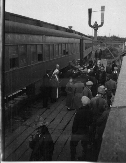
Photo 7: Settlers at Cléricy Station on the Rouyn Mines Railway, c. 1935 (Source: Bibliothèque et Archives nationales du Québec, Fond du 50e anniversaire de Cléricy)

Photo 8: A settler and his cat at Laferté Station on the Rouyn Mines Railway, 1933 (Source: Bibliothèque et Archives nationales du Québec, Fonds du Canadien national)

Photo 9: Davangus Station located at the junction of the Duparquet Branch Line with the Rouyn Mines Railway
(Source: Bibliothèque et Archives nationales du Québec)

Photo 10: Train stuck in the snow on the Rouyn Mines Railway, a short distance North of the Horne smelter in Rouyn-Noranda. For three days, from March 25 to March 27, 1947, over 10 inches of snow fell over Rouyn. The blizzard, with winds of up to 60 miles per hour, piled feet after feet of snow.
(Source: Bibliothèque et Archives nationales du Québec)

Photo 11: Train schedule for the 3 days a week passenger service from Rouyn-Noranda to Taschereau on the Rouyn Mines Railway, 1966. Note that the schedule refers to “Noranda Rouyn” as it was before the 1986 merger of the “Twin Cities” and the station was located in Noranda.
(Source: Canadian National)

Photo 12: The End of the Line – The junction of the Rouyn Mines Railway and the T&NO at Rouyn-Noranda, QC. The red line shows the Southern end of the Rouyn Mines Railway. The yellow line shows the Eastern end of the T&NO. The Glencore Horne Smelter is at the top right just outside the photo. We can see the wye connecting the Rouyn Mines Railway to the railyard serving the smelter where it also connected with the T&NO. At the bottom of the photo, we can see the position of the former Rouyn station of the T&NO (“Gare Rouyn et entrepôt du TNOR) and at the centre of the photo, the former Noranda station of the CNR (“Gare Noranda-Rouyn du Canadien national) that served the passengers on the Rouyn Mines Railway and on the CN Val-d’Or subdivision.

(Source: Ministère de l’Énergie et des Ressources, photo aérienne au 1 : 15 840, #855-128)
i An Act respecting the north-western, northern and north-eastern boundaries of the province of Quebec, 61 Victoria, Chapter 160, 1898 (https://www.canadiana.ca/view/oocihm.9_06609/2?r=0&s=1) ii Loi constituant en corporation l'Abitibi Southern Railway Company, Chapitre 106, Statuts refondus de la Province de Québec 1925, p. 307
(https://www.bibliotheque.assnat.qc.ca/DepotNumerique_v2/AffichageFichier.aspx?idf=124442) iii“Quebec Does Not Want Ontario Railway to Tap Its Gold Fields”, in Railway Age, Volume 78, April 4, 1925, p. 898
(https://books.google.com/books?id=lUIcAQAAMAAJ&pg=PA898&lpg=PA898&dq=%22Abitibi+southern+r ailway%22&source=bl&ots=BhFSpakemv&sig=ACfU3U09hy3xLf2MddBAnZL9fWLbq9_oVg&hl=fr&sa=X&v ed=2ahUKEwjY
MmD76jtAhVJRqwKHVLSCdQQ6AEwBHoECAYQAg#v=onepage&q=%22Abitibi%20southern%20railway%2 2&f=false)
iv Lebrun, Andréanne, « Le chemin de fer dans la région de Rouyn et Noranda : Un enjeu pour le contrôle du Nord-Ouest québécois », in Cap-aux-Diamants, No 112, Hiver 2013, p. 4-7 (
https://www.erudit.org/fr/revues/cd/2013-n112-cd0398/68217ac.pdf)
vLoi constituant en corporation Rouyn Mines Railway Company, Chapitre 110, Statuts refondus de la Province de Québec 1925, p. 323
(https://www.bibliotheque.assnat.qc.ca/DepotNumerique_v2/AffichageFichier.aspx?idf=124446) vi Railway Archeology, “Railways of Northern Québec (Part 3): The National Transcontinental Railway Branch Line Company (CN)”, in Rail and Transit, February 1995, p. 10
(https://s3.amazonaws.com/content.sitezoogle.com/u/131959/d0e64bf024788aac09ec3df810db355702 961734/original/ucrs-542-1995-feb375.pdf?response-content-type=application%2Fpdf&X-Amz Algorithm=AWS4-HMAC-SHA256&X-Amz-Credential=AKIAJUKM2ICUMTYS6ISA%2F20201127%2Fus-east 1%2Fs3%2Faws4_request&X-Amz-Date=20201127T005121Z&X-Amz-Expires=604800&X-Amz SignedHeaders=host&X-Amz
Signature=a871d348d4ff39a00a377d12779876d7d1e358b7de507e74e0efb585d51fb1da) vii Lebrun, Andréanne, « Le chemin de fer dans la région de Rouyn et Noranda : Un enjeu pour le contrôle du Nord-Ouest québécois », cited above.


Comments
Post a Comment