I'm a fan of the open road, and as such, I once found myself out for a drive in the middle of nowhere, crossing the
Kankakee River, when I noticed a few bridge piers jettisoning out of the water about 1000 feet west of the bridge I was crossing. They looked like railroad bridge piers.
 |
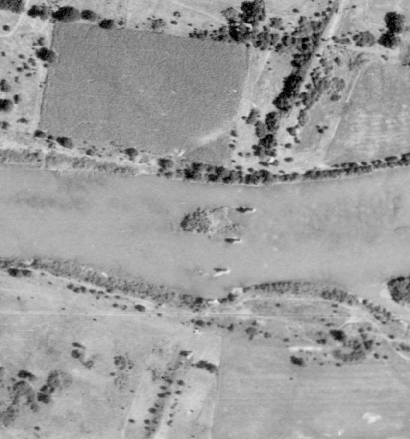
| A shot of one of the piers taken from a nearby boat launch. Warner Bridge Rd is in the background, where I originally saw these. |
This was early in
my search for abandoned railroad corridors, and I thought I had discovered a new right of way, this time in the field as opposed to on the computer, looking at Google Maps!
After coming home, I found the bridge piers, but could not find where they went, either north or south of the Kankakee River beyond a few hundred feet. Topo maps had no information either. The
Wikipedia Page for Kankakee River State Park had but one cryptic clue, "At the Chippewa Campground, hand-cut limestone pillars mark where a railway bridge was to have been built for the railroad before financiers ran out of money."
These "Happy Little Mysteries" had also been existent for an incredibly long amount of time, as I would soon find out.
So I had found a railroad line that never existed but nonetheless, has physical infrastructure. This proved problematic on my abandoned railroad map for some time, until I created a layer specifically for unbuilt rights-of-way, as how can you abandon something that never actually existed?
It took me awhile before the combined efforts of
Bill Burmaster, Bill Dittus, Russ Nelson, and others would unearth a name for the railroad, the Decatur & State Line Railway.
 |
This scar appears to be the northern end of where the D&SL Railway would have run just south of Frankfort.
|
If that name sounds familiar to you, it's because
I've discussed it before. But I decided to go back to the Kankakee River State Park and take some more pictures of these pillars.
The line was chartered in 1869, when construction over the Kankakee River, including the bridge piers, began, but the project quickly lost its financial backing partly because of the
Great Chicago Fire. The need of the fledgling railroad industry to connect major Midwestern cities, particularly Chicago and St. Louis, and this is how Decatur would come into the conversation, as that city was nearly centered on the air-line route between the two.
Grading must have been relatively extensive, because there are several traces that were visible on satellite imagery in 1939.
Interestingly, all grading, at least in the area in the vicinity of the bridge, appears to have taken place entirely in Will County.
The project was seen as a continuation of another railroad under construction at the time, namely the Decatur & East St. Louis Railroad, which was being built by the Toledo Wabash and Western Railway, or more simply the
Wabash Railroad, at the time. This association was noted in
The History of Decatur, Illinois. |
| Asher & Adams 1875 Illinois Railroad Map with the track of the then-named Chicago Decatur & St Louis Railroad highlighted, with the ending at North Bremen, near present-day Tinley Park. (David Rumsey Map Collection) |
"Because this road forms a continuation of the Decatur and East
St. Louis road in an almost perfectly air-line route between St. Louis and Chicago, passing through Decatur, near the middle,
and will be shorter by twenty-seven miles, than any other route between those cities. Twenty-five miles of the road are under
contract, and there is every reason to believe the whole road will soon be under contract, and finished during the year 1872; so that in twelve months .trains will run through from St. Louis, on
the Mississippi, to Chicago, on Lake Michigan, without delay or change."
Of course, the East St. Louis-Decatur segment was built, but not the line between Decatur and Chicago. Or at least, not that particular line.
 |
| Farthest north pier, the 4th pier, invisible from satellite imagery as it isn't over the river. |
Had the D&StL been constructed, the route would've run through Bellflower, Farmer City, Saybrook, Chatsworth, Wilton Center, and Frankfort, among other towns, before connecting with the Chicago Rock Island & Pacific.
What actually wound up happening is that the Wabash chose another route to connect Decatur to Chicago, one that ran about seven miles west of the D&StL right of way.
 |
| Looking south from the riverbank. |
I find it amazing that these pillars are still here, essentially untouched, 150 years after their construction, serving seemingly no purpose.
 |
| Beyond the brush, you can kind of see the right-of-way over the river in this picture. Sorry it isn't more clear! |
The same source in The History of Decatur, Illinois notes that there was a second line that was being built, northeasterly from Decatur, namely the Decatur Monticello and Champaign Railroad.
"[The DM&C] was incorporated a few years ago, and part of the grading done ; but work ceased for want of means. Arrangements are now
being made by some gentlemen to finish the road in a short time, and thus give Decatur another route to Chicago by way of
Champaign, there connecting with the branch of the Illinois Central."
The wording of this route is a little more complicated than necessary, in my opinion, since the road built would connect Decatur to Bement, IL, where trains could connect north along the Wabash to Monticello. From Monticello, one could follow the Illinois Central to Champaign, or continue north all the way into Chicago.
 |
From atop the northernmost pier, looking north along what would have been the ROW, there is nothing to suggest a railroad may have once ran here under different circumstances.
|
It makes sense that the Wabash didn't feel that it needed two completely different branches to serve Decatur-Chicago, even if through service to St. Louis was the ultimate goal. My guess is that they planned for each railroad in case the other one failed, and thus the bridge piers constructed for the Decatur & State Line were of relatively little consequence since only a bit of other grading was done.
 |
| Amazingly though, you can hear train horns, likely from a line about 8 miles south. |
The 1870's was a tumultuous time for the railroad industry, as it was the 2nd largest employer in the United States, behind only the agricultural industry. The rapid build up of the railroad network of the past few decades continued, and in fact became much more speculative, as wannabe railroad tycoons proposed routes and sold stocks in many railroad proposals that simply couldn't become viable assets. This was a large cause of the global
Panic of 1873.
 |
| The northernmost pier is about 15 feet higher than the rest of the nearby ground. |
I didn't want to take any pictures from Warner Bridge Rd, as it was quite busy with both cars and trucks, thus I made my way to a boat launch to try and get some wide angle shots. It was my first time using such a lens, and it shows a bit in my photos.
 |
It was difficult to get all the piers into one shot, especially facing the sun. This was the best I could do.
|
Depending on your perspective, these are either the most interesting or most boring abandoned railroad lines; those which never ran at all. In my mind, the stories of their demise before ever getting a chance to function as a route is quite interesting. But at the same time, at the end of the day, they're nothing more or less than ghost bridge pillars.
As always, I hope you enjoyed today's blog, and thanks for reading!


Fascinating reading and great sleuthing to boot...Very enjoyable
ReplyDeleteThanks for your comment. I'm hoping to have more in the future!
DeleteI was just at that site an hour or so ago and was rather
ReplyDeletemystified by it. There was no road bed running up to the
first piling squarely on land in the state park. You’d think the state
would place some kind of informational sign to explain.
Then again - it’s Illinois.
The river must run fairly shallow over that stretch.
Anyhow-
Great research on your part! Thank You -
From LJ Haberkorn's History of Chatsworth published around 1950:
ReplyDelete"The Wabash Railroad company
decided to build a railroad from
Chicago to St. Louis, Mo., which
they said would run through
Chatsworth. They employed Mr.
Charles Weiland to see how much
money our people would subscribe
to have this road run through
here. He saw the people and they
subscribed quite a sum of money.
The contract read that rails were
to be down by a certain date. The
company surveyors were at work
.surveying and stakes had been
driven through the village on 7th
street, or in other words, the
street along the west side of the
sugar factory plot.
The railroad company failed to
have these rails laid by this certain
date, so the subscribors [sic] refused
to pay what they had subscribed.
The company knew that
they could not enforce collections,
so in order to get even with these
subscribers they resurveyed the
road and built it six miles west of
here through the town of Forrest.
The large stone piers are still
standing in the Kankakee river,
showing where the railroad was to
cross on its way through Chatsworth.
The stone piers and abutments of the Wabash Bridge 8 miles down river are much more robust. These were built in 1881, ten years later ... Engineers decided to build bigger to handle increasing loads. The piers at the Kankakee River State Park look almost puny in retrospect but still beautiful in my humble opinion.
ReplyDelete