Posts

Showing posts with the label miniblog

Lockport's Abandoned Bridge Over the Des Plaines: Division Street Bridge

Image
The Division Street Bridge in Lockport, IL is currently closed to all traffic (including pedestrian traffic) and hidden behind growth. It once carried traffic across the Des Plaines River, although lost importance once the IL 7 bridge was completed. Forgotten Lands, Places and Transit photo (Jan. 2025) The bridge approach is only accessible via IL 53 on the west side of the Des Plaines River/Sanitary Ship Canal. Forgotten Lands, Places and Transit Photo (Aug. 2018) According to HistoricBridges, "this abandoned bridge which is closed to all traffic carried Division Street over Des Plaines River.  " Division Street Bridge over the Des Plaines River " - Courtesy of Lewis University. At one time an additional bridge, a swing bridge which is today gone, would have carried the street over the Sanitary and Ship Canal to the east as well.  Lockport Historic District, Chicago Sanitary & Ship Canal, Swing Bridge, Sixteenth Street, Lockport, Will County, IL ( Library of Congres...

The Chicago Kalamazoo & Saginaw Railway

Image
The Chicago Kalamazoo & Saginaw Railway was a railroad operating almost entirely within Kalamazoo County, MI, between Kalamazoo and Hastings, MI, constructed in 1883. ( Abandoned Right of Way ) It would further connect to Woodbury, MI and the Pere Marquette Railway. An informal nickname for the road was the Cuss, Kick & Swear. CK&S Locomotive at Pavilion, MI. The CK&S Railway was not designed to connect to Chicago, as the name might suggest, but it also did not connect with Saginaw either. More grandiose plans for the line came in 1887, as the company amended its articles to construct a northeasterly extension towards Saginaw, where it would connect with the Chicago and Grand Trunk Railway, but this ultimately never came to fruition.  The construction began in 1883, and the railway made its way almost entirely within Kalamazoo County, reaching as far as Hastings, MI. However, the line fell short of its intended destination, stopping only 14 miles past Hastings...

The Kansas City Clinton & Springfield Railway

Image
The Kansas City Clinton & Springfield Railway connected Olathe, KS with Ash Grove, MO along a 155 mile right of way .  KCC&S Steam Engine , c.1924. Springfield-Greene County Library. Built in 1885, it long paralleled the Kansas City and Southern Railway, which ran a quite similar route in spots. Eventually both lines became part of the St. Louis & San Francisco Railway (" The Frisco "), who would purchase the railroad in 1928, incorporating parts of the line into it's Kansas City-Springfield route, while abandoning most stretches by the mid-1930's. This section was deemed inferior and redundant to the better constructed right of way, leading to its abandonment. The 1894 USGS Clinton Map shows the routes running in parallel to each other, and offers a hint at how close these rights of way were, in some spots running beside each other. Interestingly, much of these parts of the route are underwater today as a result of the construction of the  Truman Reserv...

"LPS 1921": An Abandoned Building at Waterfall Glen Forest Preserve

Image
What appears to be some kind of stone building from early in the 20th century, today is nothing more than a creepy and haunting part of an otherwise leisurely walk along the Waterfall Glen Trail near Lemont, IL. I first encountered this structure walking with friends in 2012, at the same time that I discovered the abandoned tracks that led into Argonne National Laboratory , which began a few hundred feet east of here along the trail. My initial thought that those two finds may be connected yielded no fruit at all, which led me to the obvious question:  What exactly is this structure, and what does "LPS 1921" mean?  It almost resembles a mausoleum with an open-air roof, although my guess is that it once had a roof that has been lost to time.  This is case where the truth is rather benign, as it is the site of a former nursery, or more accurately, it is a former administration building; the nursery was along the land adjacent to the structure. This is where trees and plant...

The Washington, Alexandria, & Mt. Vernon Electric Railway

Image
The Washington, Alexandria, & Mt. Vernon Electric Railway connected Arlington, VA at present-day Rosslyn station with Mount Vernon , about 15 miles south, with service starting in 1892. ( Right of way ) The line was granted permission to connect with the District of Columbia via a barge on the Potomac, but this was never acted upon. Image: Washington, Alexandria, and Mount Vernon Electric Railway, n.d., Visual Studies Collection, Fairfax County Public Library Historical Photographs, Library of Virginia, Richmond, Virginia. Its location in eastern Virginia meant that there were many iconic American landmarks along its path, such as George Washington's Mount Vernon estate, where it ended. The line also used the present-day right-of-way of the George Washington Memorial Parkway in spots, and part of the line ran through Arlington National Cemetery and the campus of the Pentagon . The line merged with another interurban line, the Washington, Arlington & Falls Church Railway ...

The Fairchild & Northeastern Railway

Image
One of the many dozens of logging railroads in the State of Wisconsin was the Fairchild and Northeastern Railroad , which was organized in 1897. It was essentially the successor road to numerous smaller logging lines centered around Fairchild , WI,  owned by the N.C. Foster Lumber Company. The two most notable predecessor roads were the Chicago Fairchild & Eau Claire Railroad and the Forseman & Price Lumber Company Railroad, operations on which began as early as 1882 using horse power , more resembling a tramway than a conventional railroad. ( Right-of-way ) "Fairchild and Northeastern Railroad depot, with first train into Willard on the F&N Line." ( Carl R Gray Collection , c.1905) A common carrier operation, it originally connected Fairchild with Foster, WI, which ironically is northwest of Fairchild unlike the name would imply. The name actually derives from the earlier logging lines east of Fairchild that would eventually fall to the Soo Line Railroad...

George Washington Crosses the icy Delaware River

Image
On the night of Christmas Day, 1776, George Washington began  crossing the Delaware River to attack Trenton, New Jersey , creating the iconic scene immortalized in an  1851 painting . Washington crossing the Delaware River is a famous event in American history that took place during the American Revolutionary War. George Washington, then the commander-in-chief of the Continental Army, led a surprise attack against Hessian forces (German soldiers hired by the British) stationed in Trenton, New Jersey. Washington Crossing the Delaware by Emanuel Leutze, MMA-NYC, 1851 Early in the morning on Christmas, General Washington advised his troops to have food and supplies for three days of travel, and was concerned the British were planning to cross the Delaware River once it had completely frozen over. The weather was getting worse as well, turning from drizzle to rain to sleet and snow, based on a soldier's account of the day.  The greatest hazard Washington faced was ice ch...

The Montgomery and Eufaula Railroad

Image
The Montgomery and Eufaula Railroad was incorporated in 1860 to build a railroad across its namesake cities, connecting Montgomery, AL with the Chattahoochee River at Eufaula. ( Right of way )  1859 Newspaper Article proposing a Montgomery-Eufaula railroad, which was formally incorporated the following year. Construction was obviously postponed as a result of the Civil War , but would reach completion ten years later, building an 81 mile route across the eastern part of the state. Like many early railroads, it initially suffered financially, and was purchased in 1879 by the Central Rail Road and Banking Company, a predecessor to the Central of Georgia Railroad, who would reorganize the road under its original name. In 1895, the Central of Georgia Railroad formally incorporated the route into their system, adding another railroad connection between Georgia and Alabama. The route would pass on to CofG's successor, the Southern Railway , and its ultimate Class I successor, Norfolk S...

Pearl Harbor Day and the Oahu Railway & Land Company

Image
In remembrance of Pearl Harbor Day , where in 1941 thousands of American military members perished in a surprise attack, we will discuss the construction of the Harbor, in which the US Navy Railroad used narrow gauge railroad lines to both build and maintain the harbor, ship repairs, and transportation in and around the complex. Construction began in 1909. At one point, the Oahu Railway & Land Company ran within Pearl Harbor, but a spur track was installed in 1920 allowing cars between the two railroads to interchange outside of the base. More information can be found here : 

A Day in the Life: The Beatles Song Partially Inspired by Potholes

Image
There may be a lot of potholes in your town/county/state, but it's unlikely that they inspired a line in one of the most famous songs in rock history. Far from Abbey Road, but just up the road from Penny Lane, the terrible road conditions of Blackburn, Lancashire in the UK were newsworthy in the mid-1960's. This newspaper article was one of the inspirations for a new song by the Beatles at the height of their popularity after they stopped touring. "A Day in the Life" is a song by The Beatles, released on their 1967 album "Sgt. Pepper's Lonely Hearts Club Band." The song was co-written by John Lennon and Paul McCartney and is considered one of the most innovative and experimental pieces in the Beatles' catalog. Hand-written lyrics by John Lennon to "A Day in the Life". Image via Reuters. Image A short article in the Daily Mail, "The holes in our roads" noted the prevalence of potholes in Blackburn. That prompted the line "Fou...

The Thurso & Nation Valley Railway

Image
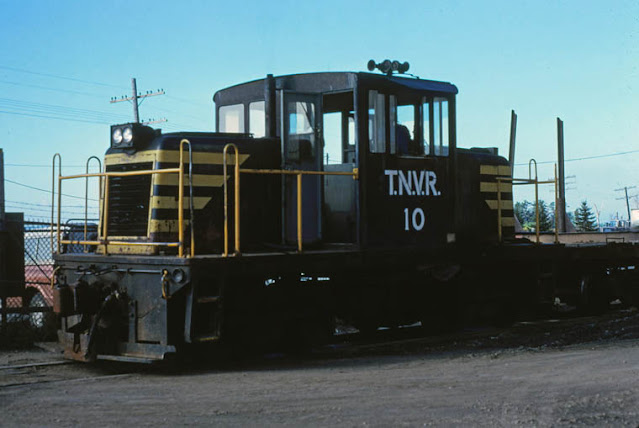
The Thurso & Nation Valley Railway was eastern North America's last logging railroad, ending service in 1986. It connected Thurso, QC with points north, with a 56 mile main line with many branches, as was common with logging lines. Thurso & Nation Valley 10 GE 50 ton Thurso September 1979 . Phtotographer: Bob Heathorn. Image via TrainWeb First surveyed in 1921, the difficult terrain took several years to fully construct, with many unforeseen obstacles along the way. Thurso & Nation Valley Railway Map It faced road competition as early as the 1950's, like every other short line and/or logging railway of the day, but nonetheless it persisted despite economic downturns occasionally closing the line temporarily. "The TNVR was discovered by railfans in the late 1960s and a number of excursions were run by the Bytown Railway Society, a group of railway enthusiasts located in the Ottawa area." (Churcher) But by 1986, operations began to cut back, endi...

The Medway Branch Railroad

Image
The Medway Branch Railroad was, as the name suggests, a short branch line from the Norfolk County Railroad at North Wrentham, MA (present-day Norfolk), running northwesterly toward Medway, MA, beginning in 1853. ( Right-of-Way ) The road offered passengers round trips between Medway to North Wrentham, where they could connect to Boston and points east. If a train wasn't running, passengers could traverse the route via a handcar. Passenger traffic did not sustain the line, and governmental funding did not come for the venture. In 1863, it came under the umbrella of the Boston Hartford & Erie, along with the Norfolk County Railroad. Just one year later, the line was abandoned, making it one of the earliest railroad abandonments in Massachusetts. Image : Boston Hartford & Erie Locomotive “Hooksett” [Medway Historical Society] Thanks as always for reading!

The Wild Mouse at Eagle Amusement Park

Image
Eagle Park was an amusement park located in Cache, OK, opening in 1957. It sat on land from an earlier amusement park known as Craterville Park. At its peak, it had numerous rides, shows, and events, and had ample campground land as well. The signature attraction was Wild Mouse, a roller coaster type of the same name . The park closed in 1985 amid rising insurance costs, and the owners not wishing to raise prices for entrance. Despite last operating in 1985, a few of the rides still stand today, most notably the Wild Mouse roller coaster. Image: Wild Mouse by Ricky Summersett, 2020. ( RCDB )

The Southern Pacific Railroad's South Line (ex-El Paso & Southwestern)

Image
The El Paso & Southwestern Railroad ran in the southwestern United States and northern Mexico during its existence. Constructed in the late 19th and early 20th century, the railway owned and operated many lines that connected to the mining industry. ( Right-of-way ) Image: Paul McGuffin, 2010, via Abandoned Rails . In 1912, the main line reached its full extent, extending from Tucson, AZ to El Paso, TX. The collapse of copper prices following World War I greatly affected the railroad,  and it was leased to the Southern Pacific Railroad in 1924. The SP used the EP&SW as a parallel main line to their own Transcontinental Route, dubbing it the "South Line".  EP&SW 168 at El Paso, TX. 1/21/1949. Image: Otto Perry via American-Rails The South Line handled both passenger and freight trains, and remained profitable through its existence. Nonetheless, the Southern Pacific chose to abandon much of the South Line in favor of a single mainline between Tuscon-E...

The Kinkora Branch of the Pennsylvania Railroad

Image
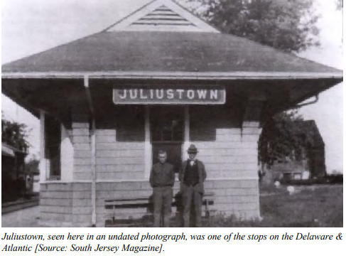
The Columbus Kinkora & Springfield Railroad was chartered in 1870 to connect New Lisbon, NJ with Kinkora, NJ, 14 miles northwest. The right of way followed the earlier Delaware & Atlantic Railroad, a much earlier rail line ran along a similar right of way, first surveyed in 1827. ( Right-of-Way ) Image: New Jersey Department of Transportation Constructed and in service by the end of 1838, "the line used mule drawn carts riding on iron strapped wood rails primarily to haul wood and charcoal between New Lisbon and Kinkora." ( Springfield Township Historical Society ) The line was abandoned at an unknown date before 1870, and the CK&S used its right of way. Almost immediately after the Columbus Kinkora & Springfield Railroad was completed, it was leased in perpetuity to the Pennsylvania Railroad, becoming the Kinkora Branch after a complicated series of mergers, acquisitions, and bankruptcies early in its existence. It officially opened in 1872. Im...

The Maryland & Pennsylvania Railroad

Image
The Maryland & Pennsylvania Railroad was an independent line that ran from Baltimore, MD to York, PA, beginning service in 1901. Meandering through the hills, it was a 77 mile long route, despite the two cities only being 45 miles apart the way a crow flies. ( Right of way ) The "Champagne Special" crossing the Sharon Trestle - Sept. 14, 1947. Image:  Maryland & Pennsylvania Railroad Preservation Society. The "Ma and Pa" as it was known informally was formed from two earlier narrow-gauge railways ; The Baltimore & Delta Railway, which became the  Baltimore and Lehigh Railway, and the York and Peach Bottom Railway, which became the York Southern. As neither was profitable, they merged to combine the route into one, and re-gaugued the right of way into standard gauge. Despite automobile competition, the railway began to be profitable post-merger, and continued to be up until the Great Depression. World War II would cement profits once again, bu...